Merry belated Christmas and happy early New Year, everyone. It's a quiet Christmas holiday for me so I haven't had much to talk about. My big excitement for December so far was attending a Messiah sing-along for the first time.
I'd never been to a Messiah sing-along before so I didn't know what to expect, but I ended up having a lot of fun. The four voices of the choir were split up around the church and I ended up sitting in front of my choir director, who coincidentally also sings bass. This turned out to be very helpful as my ability at singing unfamiliar music can be summed up as “tempo, lyrics, pitch—pick any two!” (and while I'm intimately familiar with the solo parts of the Messiah, I get lost in the dense melismas of the multi-part choruses).
Ultimately, I had a great time with it (we didn't perform the entire work, just Act I, the Hallelujah chorus, and the final two choruses) and I hope to participate again next time I get a chance. A hui hou!
Tuesday, December 29, 2015
Tuesday, December 15, 2015
PSA: Dengue Fever on the Big Island
I don't know how much coverage it's getting outside Hawaii, but here on the Big Island of Hawai‘i we're having the largest outbreak of dengue fever in a U.S. state since World War II (though there have been much larger ones in Puerto Rico and American Samoa). The number of confirmed cases passed a hundred and forty this week, with no immediate signs of slowing down. Dengue fever, if you don't know (as I didn't), is a mosquito-borne viral disease endemic in more than a hundred and ten countries, which can have potentially life-threatening effects.
This isn't the first outbreak in the island chain; the most recent outbreak happened on Maui a few decades ago, though only a total of eighty-seven cases were reported before it was contained. It remains to be seen if it can be similarly contained here on the Big Island, or whether it'll become endemic. Rather unnervingly, up to 80% of people who contract the virus are asymptomatic, so there could potentially be a lot of people on the island who've had it (and are [or were] potential spreaders) but don't know it.
The bright side (if you can call it a bright side) to all this is that the virus comes in five strains, exposure to any one of which grants lifelong immunity to that strain and is likely (as mentioned above) to cause no major problems. So far I don't think there have been any fatalities directly tied to it, despite the large number of reported cases. The problems really begin, however, when someone who's had it once contracts a different strain; then you start to get much higher chances of very dangerous complications.
The outbreak hasn't been confirmed to any particular location, and cases have been reported all over the island, so officials are warning people that infected mosquitoes could be anywhere. If you, gentle reader, are thinking of visiting the Big Island (specifically the Big Island, it hasn't shown up elsewhere yet) in the near future, you'd do well to investigate how things are going and how much progress is being made in the containment process, and take care not to get bitten. Stay safe! A hui hou!
Saturday, December 5, 2015
New Island Nishinoshima
This week I learned of a volcanic island about a thousand kilometers south of Tokyo named Nishinoshima (“western island” in Japanese). Prior to 1973, Nishinoshima was a tiny islet comprising the northwest ridge of an underwater caldera about a kilometer across and about a hundred meters beneath the ocean surface at its deepest. No eruptions at this volcano had ever been recorded in the historical record.
Starting in May 1973, however, the volcano began erupting, ultimately forming a new island to the east of the old one. The volcano fell silent a bit less than a year later, after which wave action joined the new and old islands (the new one being composed of a lot of cinder doubtless helped).
There things rested until November 2013 when the volcano began erupting again, creating another new islet off the southeast coast of the old one. This eruption continued vigorously until it had created an island larger than the one already existing. The Japanese government (which claims the island[s]) was reportedly waiting for the eruption to stop to give the new island a name, but this was rendered moot soon thereafter when the still-growing island connected to the old one, making a single island a bit over two square kilometers.
The eruption continues to this day (as far as I can tell), though it's become a lot less vigorous and may be dying down. Here's what the island looks like on Google Maps at the moment: the older part of the island is the north-western part in the lighter tan color (it's clearly recognizable in an image from December 8, 2013).

I thought it was a neat look at what the Hawaiian islands must have looked like at one point, breaching the surface of the ocean and building up to the towering edifices they became. The base Nishinoshima volcano already rises nearly three kilometers from the ocean floor and is nearly thirty kilometers across at its base, so it could presumably get a lot taller. All very interesting. A hui hou!
Starting in May 1973, however, the volcano began erupting, ultimately forming a new island to the east of the old one. The volcano fell silent a bit less than a year later, after which wave action joined the new and old islands (the new one being composed of a lot of cinder doubtless helped).
There things rested until November 2013 when the volcano began erupting again, creating another new islet off the southeast coast of the old one. This eruption continued vigorously until it had created an island larger than the one already existing. The Japanese government (which claims the island[s]) was reportedly waiting for the eruption to stop to give the new island a name, but this was rendered moot soon thereafter when the still-growing island connected to the old one, making a single island a bit over two square kilometers.
The eruption continues to this day (as far as I can tell), though it's become a lot less vigorous and may be dying down. Here's what the island looks like on Google Maps at the moment: the older part of the island is the north-western part in the lighter tan color (it's clearly recognizable in an image from December 8, 2013).
I thought it was a neat look at what the Hawaiian islands must have looked like at one point, breaching the surface of the ocean and building up to the towering edifices they became. The base Nishinoshima volcano already rises nearly three kilometers from the ocean floor and is nearly thirty kilometers across at its base, so it could presumably get a lot taller. All very interesting. A hui hou!
Saturday, November 28, 2015
Thanksgiving Breadfruit
This week I peeled a ripe breadfruit for the first time. It was quite an interesting experience!
I've cooked breadfruit before—I've even written about it on this blog—but looking back on it I realize now those breadfruit were unripe. Peeling a ripe breadfruit is a very unique experience. The closest I can liken it to is to trying to peel a lump of soft, sweet, bread dough encased in a skin something like a pear's, or perhaps a potato's—and I can definitely see where the name breadfruit comes from now! The taste is also difficult to describe. The closest thing it reminds me of is bananas, but it's very definitely its own unique, mildly sweet taste.
I've been having a rain of fruit going on in my backyard this past week, which prompted the breadfruit peeling. The avocado tree lost a small branch loaded with fruit a week ago (in addition to other ripe fruit falling), and there's been a steady stream of small earth-shaking thumps from the intermittent rain of breadfruit.
I peeled the breadfruit in order to cut it up and make a sort of hash out of it, with sautéed onions and diced Spam, but I suspect a less-ripe fruit would have been better (unripe breadfruit is kind of like a potato in texture, although it also bleeds an extremely sticky latex-like sap, so there's a lot of washing involved). I'm still trying to figure out how to prepare one best; I cooked an unripe one in the oven, but it came out looking extremely unappealing. I cooked a ripe one on the advice of a coworker, but forgot to peel it first leaving it somewhat difficult to separate from the (sap-covered) skin (it's still in my fridge while I think how best to eat it). I'm thinking of just peeling a ripe one and eating it raw at this point, but if I can find a good recipe for it I may put it up here in the future.
And finally, on a different note, happy belated Thanksgiving everyone! I spent a very relaxing Thursday topped by dinner with friends remembering all the things I'm thankful for, such as trees dropping seemingly-endless amounts of fruit in my backyard. Hau‘oli Lā Ho‘omaika‘i!
Saturday, November 14, 2015
Shore Acres State Park Pictures
In the confusion surrounding attending the International Astronomical Union session just a few days after getting home from vacation this summer I only recently realized that I had some pictures lying around on my hard drive that I'd intended to post. I put up some panoramas I'd made soon after getting back from the IAU, but forgot about some other, single pictures I'd taken. So here they are!
These pictures are from Shore Acres State Park in Oregon—once the estate of pioneer lumberman and shipbuilder Louis J. Simpson, now the site of a five-acre formal garden overlooking the Pacific Ocean. Looking over my pictures I don't seem to have been feeling like taking any wide-angle photos, as most of my pictures are more focused on individual things. So nothing showing the large-scale structure of the gardens, sorry.


And that's all for now. A hui hou!
These pictures are from Shore Acres State Park in Oregon—once the estate of pioneer lumberman and shipbuilder Louis J. Simpson, now the site of a five-acre formal garden overlooking the Pacific Ocean. Looking over my pictures I don't seem to have been feeling like taking any wide-angle photos, as most of my pictures are more focused on individual things. So nothing showing the large-scale structure of the gardens, sorry.

These aren't real birds, they're just statues—but very nice-looking ones.

Slightly-wider view of the pond they reside in.

Do not adjust your monitor! This picture is not upside down—it's a reflection showing the lovely conifers surrounding the park.

The park had a small greenhouse full of various flowers and plants. This particular one caught my eye for its spiral leaf patterns. (The text says “rex begonia 'Escargot'”.)

Another picture of a second plant of the same type, showing off those radical foliage helices.
Saturday, October 24, 2015
Rainbow Falls Photos
This week on my way home from work I decided to stop at Rainbow Falls on a whim. Since I moved last year the falls are a lot closer to my house, so it's not very far out of my way. About four days earlier we'd had a powerful thunderstorm all day, and while we get many days of rain here in Hilo thunderstorms are pretty rare—perhaps ten or fewer a year. The large amount of rain from upstream had swelled the falls to a thunderous roar, and with the sun going down but still above the horizon I decided to shoot some photos in the picturesque light.
This one's from the outlook spot just a short walk from the parking lot:

And this is from the path that climbs up to above the waterfall's head—if you look you can see someone silhouetted in the previous picture, standing very close to where I took this next one:

Fun fact: my profile photo up there was actually taken at Rainbow Falls! Though it's been cropped so you can't actually see the falls in it. And it's about six years old at this point...maybe it's time for me to think about updating it (not that I look vastly different or anything).
Sunday, October 18, 2015
An Astrophysicist Reviews: The Martian
Yesterday I went to see The Martian with my friend Graham from work. Overall I had a pretty good time with it, and I liked the happy ending. I can't really talk about what I want to without spoiling the plot, so consider the rest of this post one big spoiler warning.
If you saw a trailer for The Martian, you probably already got the gist of the movie. The Ares III mission (third in a series of five manned mission to Mars) encounters a mission-scrubbing sandstorm only twelve days into their mission. During the emergency evacuation one crew member (Mark Watney) gets lost in the sandstorm after getting hit by a flying communications antenna and is (quite reasonably) presumed dead after his suit reports a suit breach, leading the rest of the crew to abandon Mars and head back to Earth. Mark turns out to be alive, amazingly (the blood from where he got impaled having sealed the small hole in his suit), and most of the rest of the movie deals with his attempts to survive until he can be rescued. Luckily, as this was a series of planned missions, Ares IV is already set to land 3800 kilometers from his position in a few years, leading to the idea of getting there to meet it when it arrives. The rations left behind in the evacuation won't stretch that long, but a serendipitous discovery of viable potatoes among the rations leads to him growing them and giving hope that he can survive long enough to modify the rover (also left behind) to be capable of traveling to the landing site.
It takes a few months for anyone to notice he's still alive based on satellite photos of Mars, but when they do they manage to get communications up and running between NASA and Mark. NASA fast-tracks sending the scheduled pre-delivery of food for the Ares IV mission in order to get it to Mark faster, especially after a freak explosion blows up his growing habitat and destroys his potato crop, leaving him with the unenviable prospect of running out of food in a very definite amount of time.
Meanwhile, the rest of the crew of the Ares III are still on their several-month journey back to Earth in the Hermes crew vessel. An astrodynamicist at NASA realizes that the Hermes could potentially slingshot around Earth and get back to Mars fast enough to save Mark as a backup in case the food shipment doesn't make it. (Turns out the Ares IV ascent vehicle has already been landed at the proposed landing site on Mars, since it could be launched ahead of time and means the actual Ares IV mission doesn't need to bother with bringing it along; Mark could take it up and rendezvous with the Hermes as it slingshots again around Mars on its way back to Earth.) This idea is floated in a secret meeting, but is rejected for putting the rest of the crew in additional danger (not to mention several more months of spaceflight time). However, when the rocket carrying the food package explodes during launch the Ares III mission director secretly sends the crew details of the maneuver, whereupon they unanimously vote to mutiny and perform the maneuver against NASA's orders.
Ultimately, the Hermes makes it back to Mars in time for Mark to make it to the Ares IV ascent vehicle before starving, where he strips a frankly ludicrous amount of material out of the ascent vehicle in order to make it light enough to reach the speed necessary to rendezvous with the Hermes (as in, he strips out all of the manual controls leaving it controlled remotely from the Hermes, and even the windows and airlock, performing the ascent in his spacesuit with a tarp over the windows). After a climactic rescue scene Mark is saved, and in the epilogue it's shown that everyone made it back to Earth safely and Mark has taken up teaching future astronauts.
Think Apollo 13 meets Robinson Crusoe.
Now, most of the time, the science was quite good, as you would hope for a movie where almost all of the tension comes from butting up against the laws of nature. Things like burning hydrogen to get water (and causing an explosion due to unaccounted-for excess oxygen), space scenes shot in zero-g conditions (although the Hermes also has rotating sections where people can walk around normally due to centrifugal force), and a homemade bomb made of sugar mentioned as being “four times more powerful than a stick of dynamite” (which is entirely believable, given the vast amounts of energy in food; thankfully, it doesn't easily burn fast enough to explode under normal conditions). The shots of Mars were also particularly gorgeous, especially in the 3D version I saw, which worked well; the 3D was used to good effect rather than being a mere gimmick, and was never used to “in your face” type things.
As an astronomer, however, several details stuck out to me while watching. At least twice, the Martian night sky is shown with a small crescent moon hanging in space. While pretty, it's also unrealistic because Mars' two moons Phobos and Deimos are both tiny, and far too small to be seen as anything other than star-like points (they're also irregularly shaped like asteroids, so they wouldn't have a nice crescent like the Moon does here on Earth). There was also a beautiful shot of a Martian sunset…which looked suspiciously like a sunset on Earth, with a blue sky fading to red around the Sun. Interestingly, it's almost the exact opposite on Mars: the sky is normally red due to ever-present dust in the atmosphere, while fading to blue around the Sun at sunset and sunrise. The atmosphere on Mars is only about 1% as thick as Earth's at ground level, so it's usually too thin for there to be enough Rayleigh scattering to produce the blue skies here on Earth. However, at sunrise or sunset the Sun's light passes through enough of the Martian atmosphere to create a pale blue color, as seen in the picture below. (On Earth the extra atmosphere at those time scatters so much blue light out that what's left appears red or orange.)

Another thing I noticed is that the movie tries to have it both ways with regards to how thick Mars' atmosphere is. In the first few minutes of the movie, the sandstorm that kicks everything off both rips off a communication dish and takes out Mark with it, and presents a credible threat of blowing over the ascent vehicle. Yet near the end of the film as Mark is preparing to ride an Ares IV ascent vehicle that has had even its windows and airlock removed in order to lighten it, it's pointed out that the Martian atmosphere is thin enough that you could feasibly pull such a thing off due to air resistance being essentially non-existent. I'm not familiar enough with the fluid dynamics of the Martian atmosphere to say anything myself, but I've read that in reality even a fierce sandstorm on Mars would feel like a light breeze and wouldn't be able to tip over a large metal ship. The highest atmospheric density on Mars is only 0.6% that of Earth's, so I believe it. Mars' famous planet-wide sandstorms work because of the lower Martian gravity, not because the wind is so strong. And speaking of gravity…
…as a physicist, I couldn't help but notice how Mars has Earth gravity the whole time. The surface gravity on Mars is just 3.7 m/s², a mere 37.6% of Earth's 9.8 m/s². Obviously the movie was filmed on Earth (Wadi Rum in Jordan standing in for Mars), and it'd be to impossible to change something like that, so this isn't a fault of the movie in any way—it just wouldn't be possible to make it look realistic. The fact that something so minor is what I kept noticing really says something about how good the rest of the science was.
Interestingly, during the part where the crew on board the Hermes votes to mutiny and perform the maneuver to return to Mars against NASA's orders to save Mark, the commander says something to the effect of “if we do this, none of us are likely to ever fly again.” This may sound like mere dramatic oratory (although it's justified in the context), but it turns out this has actually happened: in at least two cases crews of astronauts (on Apollo 7 and Skylab 4) have mutinied while in space, and both times no one on the crew ever flew in space again, as eloquently explained in the videos below.
Overall, as I said, I found it a pretty good film, though I couldn't watch the early scene where Mark performs self-surgery to remove a bit of metal from his abdomen from where a spike on the communication array impaled him with nothing but local anesthetic (queasiness is why I'm an astronomer and not a doctor!). I laughed at the part where, in the secret meeting to explain the maneuver for the Hermes, the guy who came up with the maneuver calls it “Project Elrond” and while one of the people in the meeting is trying to figure out what “Elrond” means the normally staid and stoic director of NASA pipes up from the background to say “If this is the council of Elrond, I want my code name to be Glorfindel.” And I especially winced in sympathy at Mark's line “I ran out of ketchup seven days ago” said while eating a potato. Surely that would have to be the worst thing about being stranded on Mars: running out of ketchup. A hui hou!
If you saw a trailer for The Martian, you probably already got the gist of the movie. The Ares III mission (third in a series of five manned mission to Mars) encounters a mission-scrubbing sandstorm only twelve days into their mission. During the emergency evacuation one crew member (Mark Watney) gets lost in the sandstorm after getting hit by a flying communications antenna and is (quite reasonably) presumed dead after his suit reports a suit breach, leading the rest of the crew to abandon Mars and head back to Earth. Mark turns out to be alive, amazingly (the blood from where he got impaled having sealed the small hole in his suit), and most of the rest of the movie deals with his attempts to survive until he can be rescued. Luckily, as this was a series of planned missions, Ares IV is already set to land 3800 kilometers from his position in a few years, leading to the idea of getting there to meet it when it arrives. The rations left behind in the evacuation won't stretch that long, but a serendipitous discovery of viable potatoes among the rations leads to him growing them and giving hope that he can survive long enough to modify the rover (also left behind) to be capable of traveling to the landing site.
It takes a few months for anyone to notice he's still alive based on satellite photos of Mars, but when they do they manage to get communications up and running between NASA and Mark. NASA fast-tracks sending the scheduled pre-delivery of food for the Ares IV mission in order to get it to Mark faster, especially after a freak explosion blows up his growing habitat and destroys his potato crop, leaving him with the unenviable prospect of running out of food in a very definite amount of time.
Meanwhile, the rest of the crew of the Ares III are still on their several-month journey back to Earth in the Hermes crew vessel. An astrodynamicist at NASA realizes that the Hermes could potentially slingshot around Earth and get back to Mars fast enough to save Mark as a backup in case the food shipment doesn't make it. (Turns out the Ares IV ascent vehicle has already been landed at the proposed landing site on Mars, since it could be launched ahead of time and means the actual Ares IV mission doesn't need to bother with bringing it along; Mark could take it up and rendezvous with the Hermes as it slingshots again around Mars on its way back to Earth.) This idea is floated in a secret meeting, but is rejected for putting the rest of the crew in additional danger (not to mention several more months of spaceflight time). However, when the rocket carrying the food package explodes during launch the Ares III mission director secretly sends the crew details of the maneuver, whereupon they unanimously vote to mutiny and perform the maneuver against NASA's orders.
Ultimately, the Hermes makes it back to Mars in time for Mark to make it to the Ares IV ascent vehicle before starving, where he strips a frankly ludicrous amount of material out of the ascent vehicle in order to make it light enough to reach the speed necessary to rendezvous with the Hermes (as in, he strips out all of the manual controls leaving it controlled remotely from the Hermes, and even the windows and airlock, performing the ascent in his spacesuit with a tarp over the windows). After a climactic rescue scene Mark is saved, and in the epilogue it's shown that everyone made it back to Earth safely and Mark has taken up teaching future astronauts.
Think Apollo 13 meets Robinson Crusoe.
Now, most of the time, the science was quite good, as you would hope for a movie where almost all of the tension comes from butting up against the laws of nature. Things like burning hydrogen to get water (and causing an explosion due to unaccounted-for excess oxygen), space scenes shot in zero-g conditions (although the Hermes also has rotating sections where people can walk around normally due to centrifugal force), and a homemade bomb made of sugar mentioned as being “four times more powerful than a stick of dynamite” (which is entirely believable, given the vast amounts of energy in food; thankfully, it doesn't easily burn fast enough to explode under normal conditions). The shots of Mars were also particularly gorgeous, especially in the 3D version I saw, which worked well; the 3D was used to good effect rather than being a mere gimmick, and was never used to “in your face” type things.
As an astronomer, however, several details stuck out to me while watching. At least twice, the Martian night sky is shown with a small crescent moon hanging in space. While pretty, it's also unrealistic because Mars' two moons Phobos and Deimos are both tiny, and far too small to be seen as anything other than star-like points (they're also irregularly shaped like asteroids, so they wouldn't have a nice crescent like the Moon does here on Earth). There was also a beautiful shot of a Martian sunset…which looked suspiciously like a sunset on Earth, with a blue sky fading to red around the Sun. Interestingly, it's almost the exact opposite on Mars: the sky is normally red due to ever-present dust in the atmosphere, while fading to blue around the Sun at sunset and sunrise. The atmosphere on Mars is only about 1% as thick as Earth's at ground level, so it's usually too thin for there to be enough Rayleigh scattering to produce the blue skies here on Earth. However, at sunrise or sunset the Sun's light passes through enough of the Martian atmosphere to create a pale blue color, as seen in the picture below. (On Earth the extra atmosphere at those time scatters so much blue light out that what's left appears red or orange.)
Another thing I noticed is that the movie tries to have it both ways with regards to how thick Mars' atmosphere is. In the first few minutes of the movie, the sandstorm that kicks everything off both rips off a communication dish and takes out Mark with it, and presents a credible threat of blowing over the ascent vehicle. Yet near the end of the film as Mark is preparing to ride an Ares IV ascent vehicle that has had even its windows and airlock removed in order to lighten it, it's pointed out that the Martian atmosphere is thin enough that you could feasibly pull such a thing off due to air resistance being essentially non-existent. I'm not familiar enough with the fluid dynamics of the Martian atmosphere to say anything myself, but I've read that in reality even a fierce sandstorm on Mars would feel like a light breeze and wouldn't be able to tip over a large metal ship. The highest atmospheric density on Mars is only 0.6% that of Earth's, so I believe it. Mars' famous planet-wide sandstorms work because of the lower Martian gravity, not because the wind is so strong. And speaking of gravity…
…as a physicist, I couldn't help but notice how Mars has Earth gravity the whole time. The surface gravity on Mars is just 3.7 m/s², a mere 37.6% of Earth's 9.8 m/s². Obviously the movie was filmed on Earth (Wadi Rum in Jordan standing in for Mars), and it'd be to impossible to change something like that, so this isn't a fault of the movie in any way—it just wouldn't be possible to make it look realistic. The fact that something so minor is what I kept noticing really says something about how good the rest of the science was.
Interestingly, during the part where the crew on board the Hermes votes to mutiny and perform the maneuver to return to Mars against NASA's orders to save Mark, the commander says something to the effect of “if we do this, none of us are likely to ever fly again.” This may sound like mere dramatic oratory (although it's justified in the context), but it turns out this has actually happened: in at least two cases crews of astronauts (on Apollo 7 and Skylab 4) have mutinied while in space, and both times no one on the crew ever flew in space again, as eloquently explained in the videos below.
Overall, as I said, I found it a pretty good film, though I couldn't watch the early scene where Mark performs self-surgery to remove a bit of metal from his abdomen from where a spike on the communication array impaled him with nothing but local anesthetic (queasiness is why I'm an astronomer and not a doctor!). I laughed at the part where, in the secret meeting to explain the maneuver for the Hermes, the guy who came up with the maneuver calls it “Project Elrond” and while one of the people in the meeting is trying to figure out what “Elrond” means the normally staid and stoic director of NASA pipes up from the background to say “If this is the council of Elrond, I want my code name to be Glorfindel.” And I especially winced in sympathy at Mark's line “I ran out of ketchup seven days ago” said while eating a potato. Surely that would have to be the worst thing about being stranded on Mars: running out of ketchup. A hui hou!
Sunday, October 11, 2015
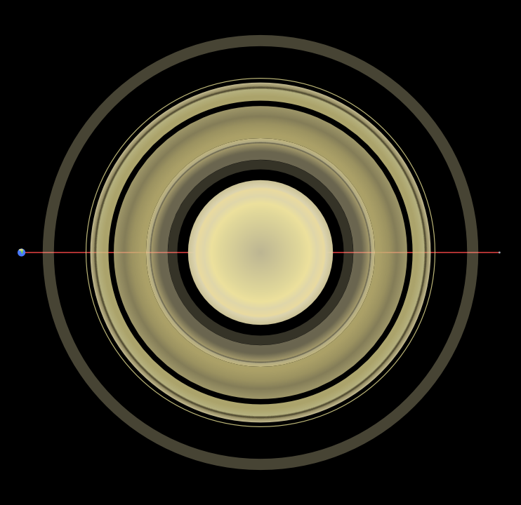
Astro-Art: Saturn in SVG
When I put together those pictures of Saturn I used to illustrate the scale of Saturn's ring system last month I went to a lot of trouble to make all the rings consist of two mirrored halves, with the intention of using them to make the illustration in perspective (by hiding one set behind Saturn, then squashing both sets symmetrically inwards vertically, if you're curious). Along the way I decided I liked the straight-on overhead view better and ended up not doing it, but the capability remained, so today I decided to blow the virtual dust off the file and see what I could make of it. I had to make a new radial gradient for Saturn, but I think it came out looking pretty nice:

(Despite the title, this is just a plain old PNG image, as Blogger unfortunately doesn't take SVG images directly. But the original is SVG, anyway. See how many of the rings mentioned in my previous post you can spot here!)
Sunday, September 27, 2015
Rocks in Space: Finding Asteroids in the Solar System
I came across a neat video on YouTube the other day, showing visually the discovery of all the asteroids found since 1970 up to the present.
In this video the Sun is at the center, with the inner planets (and occasionally Jupiter) seen rotating around it from a position above the plane of the solar system (so looking down on the Earth's North Pole). The planets aren't labeled, but it's easy to count outwards from the Sun to find Earth. At the start of the video in 1970 all of the 4,422 asteroids known at that point are marked with tiny dots. (It's best to watch on the highest resolution you can, otherwise they're hard to see.) As time unfolds, asteroid discoveries are marked with bright white dots, before fading to a fainter color. Yellow and red dots (I'm guessing) are asteroids that come close to Earth, or Near-Earth Objects (NEOs).
Later in the video you might notice asteroids in the same orbit as Jupiter. These are known as the Trojan asteroids. These asteroids orbit the Sun in roughly the same orbit as Jupiter, but 60° either ahead or behind of it. The name comes from the fact that early on the first few discovered were given names from the Trojan War (starting with 588 Achilles), and it was proposed to continue with the naming scheme and give them all such names. The naming scheme even extends to location: asteroids ahead of Jupiter are given names from the Greek side of the war, while those trailing it are given names from the Trojan side. (Though amusingly, there are two out-of-place names from before this particular convention was adopted: Patroclus is found among the Trojans, and Hektor among the Greeks.)
The term Trojan asteroid originally referred to just the asteroids in the orbit of Jupiter, but when other asteroids sharing similar orbits with other planets were found the term expanded to encompass them as well. Currently Trojan asteroids are known for Earth (1), Mars (7), Jupiter (6,000+), Uranus (1), and Neptune (13).
As for why Trojan asteroids are generally found around 60° in front of or behind the planets they share an orbit with, that has to do with gravity, the three-body problem, and Lagrange points, and really deserves a blog post to itself sometime.
And finally, while watching these nifty visualizations, just keep in mind the fact that sizes are not to scale. In reality, while it looks like the asteroid belt is a swirling maelstrom of space debris, there are typically millions of miles (or kilometers!) between any two asteroids. There may be a lot of rocks out there, but there's an even larger volume of space to hold them. A hui hou!
Monday, September 14, 2015
Saturn's Rings and the Earth-Moon Distance
A few weeks ago I happened to hear offhand that Saturn and its rings would fit nicely in the space between the Earth and Moon. Being the visual-oriented person I am, I decided to go ahead and make a picture to put them in perspective, and figured I'd share.
First of all, a quick primer on the nomenclature of Saturn's rings. The rings are labeled alphabetically in order of discovery, although the A, B, and C rings were all discovered basically at the same time and the decision to name them working outward in towards the planet was pretty much arbitrary.

Technically the F ring is too thin to be shown here; it's only about 30–500 km thick which means it's about 40–400 times thinner than shown here. The relative brightnesses of the rings is also only approximate; the G ring (and even D ring) are also fainter than shown here, and aren't visible to the naked eye. They were only discovered with photography from various interplanetary probes after 1979 (as was the F ring). The F ring is the outermost of the “discrete” rings; beyond it, the rings are diffuse and may have moons orbiting embedded within them.
The astute among you might have noticed that there is a distinct lack of an E ring in the above image. Don't worry, we'll come back to that. Anyway, let's see how these rings stack up against the average Earth-Moon distance:

With an average separation distance between them of about 358,000 km, we can see that the Earth and the Moon nicely frame Saturn and its main rings there. It also gives a good idea of the size of Saturn relative to Earth.
But what about that E ring I glossed over a paragraph ago? Turns out the E ring is outside the G ring and extremely large, but like the G ring it's also extremely faint and diffuse.
Anyway, here's the E ring in all its glory (I've left the Earth, Moon, and the line between them in place):

Yeah, the E ring's pretty wide (and again, it's so diffuse that it's not visible to the naked eye). Its outer edge is just within the orbit of Saturn's largest moon, Titan. As you can see (or maybe not), the E ring's diameter is around twice as large as the average Earth-Moon distance.
But believe it or not, that's not all of Saturn's rings! There are a few more ringlets between the G and E ring that are too thin to show here, but there's another ring outside the E ring that's even larger and even more diffuse. This ring was only discovered in October 2009, and is known as the Phoebe ring after Saturn's unusual moon Phoebe which orbits just outside of it in a retrograde orbit. Here it is, with the rest of the ring system for comparison:

Yep, that little disc in the center is the E ring we just saw in the last picture—with the inner ring system and Saturn within that. This ring is really large. In fact, unlike the other rings which have a maximum thickness on the order of tens to maybe hundreds of meters, the Phoebe ring has a thickness around forty times greater than the radius of Saturn itself. In other words, this ring is thicker than the entire diameter of the E ring.
So there you have it! Saturn and its fascinating ring system, and how it compares to the distance between the Earth and the Moon. Hope you found it as interesting as I did putting these images together. A hui hou!
First of all, a quick primer on the nomenclature of Saturn's rings. The rings are labeled alphabetically in order of discovery, although the A, B, and C rings were all discovered basically at the same time and the decision to name them working outward in towards the planet was pretty much arbitrary.
Technically the F ring is too thin to be shown here; it's only about 30–500 km thick which means it's about 40–400 times thinner than shown here. The relative brightnesses of the rings is also only approximate; the G ring (and even D ring) are also fainter than shown here, and aren't visible to the naked eye. They were only discovered with photography from various interplanetary probes after 1979 (as was the F ring). The F ring is the outermost of the “discrete” rings; beyond it, the rings are diffuse and may have moons orbiting embedded within them.
The astute among you might have noticed that there is a distinct lack of an E ring in the above image. Don't worry, we'll come back to that. Anyway, let's see how these rings stack up against the average Earth-Moon distance:
With an average separation distance between them of about 358,000 km, we can see that the Earth and the Moon nicely frame Saturn and its main rings there. It also gives a good idea of the size of Saturn relative to Earth.
But what about that E ring I glossed over a paragraph ago? Turns out the E ring is outside the G ring and extremely large, but like the G ring it's also extremely faint and diffuse.
Anyway, here's the E ring in all its glory (I've left the Earth, Moon, and the line between them in place):
Yeah, the E ring's pretty wide (and again, it's so diffuse that it's not visible to the naked eye). Its outer edge is just within the orbit of Saturn's largest moon, Titan. As you can see (or maybe not), the E ring's diameter is around twice as large as the average Earth-Moon distance.
But believe it or not, that's not all of Saturn's rings! There are a few more ringlets between the G and E ring that are too thin to show here, but there's another ring outside the E ring that's even larger and even more diffuse. This ring was only discovered in October 2009, and is known as the Phoebe ring after Saturn's unusual moon Phoebe which orbits just outside of it in a retrograde orbit. Here it is, with the rest of the ring system for comparison:

Yep, that little disc in the center is the E ring we just saw in the last picture—with the inner ring system and Saturn within that. This ring is really large. In fact, unlike the other rings which have a maximum thickness on the order of tens to maybe hundreds of meters, the Phoebe ring has a thickness around forty times greater than the radius of Saturn itself. In other words, this ring is thicker than the entire diameter of the E ring.
So there you have it! Saturn and its fascinating ring system, and how it compares to the distance between the Earth and the Moon. Hope you found it as interesting as I did putting these images together. A hui hou!
Sunday, August 30, 2015
A Couple Panoramas of the Oregon Coast
While attending the family reunion I was on vacation for in Oregon in July I got the chance to take a trip up the Oregon coast. There's some really gorgeous scenery up there, and I took the opportunity to take some pictures for panoramas. I finally got around to putting them together this weekend and thought I'd share them.
First off here's a panorama of Simpson Reef, a small reef off the Oregon coast.
Edit (3/19/18): This panorama now is the version made using Hugin, but you can mouse over it to see the original version!
The largest island visible near the center of the image is Shell Island, and while you can't see it at this resolution the beach at its base was absolutely covered in sea lions. From my location at the overlook spot I could hear a constant faint cacophony of cries from the mass of pinnipeds sunning themselves on the strand. The reef is part of the Oregon Islands National Wildlife Refuge and Oregon Islands Wilderness, and its constituent islands are also important breeding grounds for lots of seabirds.
This panorama isn't of anywhere particular (it's just a bit up the coast from Shore Acres State Park), but I loved the landscape.
Edit (3/19/18): Again, this is the new version made with Hugin, mouse over it to see the original hand-made one!
It's hard to see at this resolution, but there are some neat concretions visible down close to the shoreline. Concretions are masses of matter harder than the surrounding sedimentary layers formed by precipitations of mineral cement, and look like roughly spherical lumps protruding from the softer stone around them as it erodes faster. The whole coastline here shows some interesting weathering and erosion features.
It occurred to me while making these panoramas just how much work goes into making them, and I'm considering possibly doing a little walkthrough/tutorial on what I do to put these together in the future. Anyway, enjoy the landscapes. A hui hou!
First off here's a panorama of Simpson Reef, a small reef off the Oregon coast.
 |
| Mouse over for original, click for larger version. |
This panorama isn't of anywhere particular (it's just a bit up the coast from Shore Acres State Park), but I loved the landscape.
 |
| Mouse over for original, click for larger version. |
It occurred to me while making these panoramas just how much work goes into making them, and I'm considering possibly doing a little walkthrough/tutorial on what I do to put these together in the future. Anyway, enjoy the landscapes. A hui hou!
Saturday, August 22, 2015
Ice Skating in Hawaii
It's been a little bit quiet around here as I spent pretty much the last two weeks of July and the first week of August away, first back on the west coast for a family reunion then in Honolulu for a business trip. The triennial IAU (International Astronomical Union) conference was back in the U.S. for the first time in twenty-five years, and as a new organization EAO wanted to have a booth there to help get our name out. Which is why I got to spend a fun week in Honolulu talking to people about the JCMT!
Despite flying through the Honolulu airport twice a year on average for the past six years this was my first time actually outside the airport. It was a bit of a shock just how different it was from Hilo. O‘ahu has a lot of basically flat area, something that is in short supply on Hawai‘i, and it was discombobulating to drive for miles with essentially no elevation change. Though the half-mile walk to the convention center from my hotel was flat rather than uphill, so I'm not complaining.
Check out our nifty booth!

That fantastic diorama of the summit of Mauna Kea on the left there belongs to Subaru with whom we were sharing a booth, and boy, was it popular throughout the conference. It was really nice to be able to point out to people exactly where the JCMT (and everything else) on the summit was.
While I was there, I got to do something most people don't associate with Hawaii: ice skating! My co-worker and friend from college that I went over with, Will, suggested it, so one night after the convention was over we took the bus over the skating rink. I even took a really poor picture as proof!

Yeah, that picture didn't really come out well. I blame my slightly deranged expression on the fact that I was standing on ice skates and concentrating on not falling over. It was a lot of work, and there was much comedic flailing as I rounded the rink a few times, but at least I managed not to fall down over the course of the hour I spent on the ice. All in all, a fun experience. Look forward to some pictures from my time in Oregon soon!
Saturday, August 8, 2015
Adding Cubits to your Lifespan
In my Bible-reading this morning I ran across Matthew 6:27 where Jesus says “And who of you by worrying can add a single πῆχυν to his ἡλικίαν?” This is an interesting verse to translate, because ἡλικίαν (pronounced heylikian, with the i's sounding like the i in machine) is usually translated as something like ‘lifespan,’ but πῆχυν (pronounced peychoon, where the ‘ch’ sounds like it does in German ‘Bach’ or Scottish ‘loch’) is a very straightforward word meaning ‘cubit.’
On the face of it, this doesn't make grammatical sense; how do you add a cubit to your lifespan? This has lead to two divergent translations I've seen: one involves translating πῆχυν as ‘hour’ (despite there being another definite word for hour, ὥρα [hora]), while the other translates ἡλικίαν as ‘height.’
Neither of these translations sound really good to my ear, so I when I came to the passage this morning I decided to go back to the literal meaning of both words and incorporate insights from relativity theory. Relativity tells us that time is simply another dimension like the three dimensions of space (which are inextricably linked in a four-dimensional spacetime), and that by using the speed of light as a conversion factor we can use units of measurement for space to measure time, and vice versa. What does a ‘second of distance’ mean? It's the distance light travels in one seconds, approximately 186,000 miles or 300,000 kilometers. And similarly, one ‘meter of time’ is the amount of time it takes light to travel one meter, approximately three nanoseconds.
A cubit, by the way, is very close to half a meter, so what Jesus is basically saying here is that you can't add even a nanosecond and a half to your life by worrying—so don't worry, because your Heavenly Father is in control. A hui hou!
Sunday, July 26, 2015
Diagramming Noun Adjunct-Heavy Sentences
I learned to diagram sentences from my mother (a Linguistics major in college), but didn't appreciate it much at the time (to be fair, my mother didn't appreciate it either until she began teaching me and my sister). Until, that is, I ran across a sentence in the local newspaper that made me want to diagram it.
The sentence in question was “This is not an administrative license revocation matter.” (It has to do with the ongoing investigation into whether the mayor of Hilo inappropriately used government funds for personal benefit.) It's not particularly long—no complicated compound sentence or anything—it was merely the noun phrase in the predicate that attracted me. It took me quite a bit of research, though, to figure out what all those nouns near the end are.
The ending noun phrase “administrative license revocation matter” has what looks like a couple of nested noun adjuncts, which is where a noun modifies another noun the way an adjective normally would. “Administrative” is an adjective modifying “license,” which is itself serving as a noun adjunct modifying “revocation,” which entire phrase is modifying “matter” at the end.
And yet, nowhere could I find how to diagram something like that. One website helpfully told me that noun adjuncts are diagrammed like adjectives—on a diagonal line beneath the noun they modify—but I couldn't see any way to chain multiple noun adjuncts together.
After some time pondering the matter and scratching my head, I decided to

If any of you out there are more familiar with sentence diagramming and would like to point out how it should actually be done, feel free to sound off in the comments! A hui hou!
Wednesday, July 15, 2015
Why New Horizons Can See Pluto, and Hubble Can't
About a day ago the New Horizons space probe finally reached the end of its nine-year journey through space and accomplished its mission: a fly-by of Pluto, marking the first time humanity has gotten to see the surface of this mysterious minor planet.
And what a surface it is!
Just look at all those surface features! There's a large icy vaguely heart-shaped region in the middle (which reminds me of Antarctica for some reason). It's flanked on two sides by extremely dark patches. On the right side of the picture long shadows betray the presence of fierce mountain ranges jutting from the smooth plains around them. What looks like a long canyon sits on the left side of the image, while vast smooth plains fill the top half. Speaking of which, there's a noticeable dearth of obvious impact craters—I can spot a few, but it's nothing like, say, Mercury, or our Moon.
When I was growing up in the 90's, from as early as I could remember I was fascinated by other planets. This was the beginning of my lifelong journey to become an astronomer, as I devoured every bit of reading material I could get my hands on pertaining to the solar system. This was right after the two Voyager probes had completed their missions to the outer planets (Voyager 2 flew by Neptune the year I was born, 1989), so there was an eclectic mixture of information in the books I read, depending on how old they were and how up-to-date their information was. (Looking back, I realize this was excellent training for my young self in sifting multiple conflicting sources of information and piecing together a coherent narrative from them. Huh.)
The newer books had pictures of the outer planets and their moons from the Voyager probes that were of resoundingly better quality than the ones before it. Those two probes taught us so much about the planets that we simply couldn't see from our vantage point on Earth. The point to this rather rambling divergence is that I know now what people must have felt like when those first pictures of each new planet were coming back. If you're not familiar with our previous best images of Pluto, let me show you one (courtesy of the Hubble Space Telescope):
To be clear, the actual photos of Pluto are those two small pictures at the top; the larger ones are computer models extrapolating from those pictures. These were among the best images of Pluto we had until yesterday. And yes, that's a photo from 1996, but we didn't really get any better ones in the intervening time period; here's another one from 2012:
The letters WFC3 at the top of this image stand for Wide Field Camera 3, the last and most technologically advanced camera installed on the Hubble Space Telescope, so this is as good it's possible for Hubble to get. With that in mind it's easier to appreciate just how amazing the pictures from New Horizons are.
“But hang on,” you may be saying, “why can't Hubble get better pictures of Pluto? It gets all those amazing pictures of galaxies, and they're a lot further away than Pluto is!”
If you're asking this, then you're in luck, because I asked myself the same thing driving home from work today. The apparent discrepancy comes about due to us humans not having a good intuitive sense about sizes and distances so far outside our everyday experiences. To really get a feel for why things are the way they are, we need to use math.
My idea for this was find the diameters and distances to Pluto and a nice galaxy that Hubble had photographed, take their ratios, and see just how much bigger the galaxy would appear on the sky. Then while researching these bits of information in order to write this post I discovered that an astronomer named Emily Lakdawalla had already done exactly that. So rather than write up another post that would say pretty much the exact same thing, you get to go read her blog post. (She also already has an excellent image showing the relative sizes of a lot of Pluto-sized bodies in the solar system using the newest images of Pluto and Charon!)
I had an idea to take a picture of a galaxy and a picture of Pluto and shrink the Pluto picture down and stick it on the galaxy picture to see how they compare, but I did a quick back-of-the-envelope calculation with a galaxy picture I picked out and discovered that Pluto would be about two pixels across (which agrees quite well with the conclusion in Emily's blog post that Pluto would theoretically cover less than two pixels of Hubble's WFC3). I tried sticking a little 2×2 bright green square into the image, and could barely make it out at 100% resolution even knowing where to look. So I figured it wouldn't be especially interesting to show given that putting the picture up on this blog would further shrink it. Sorry.
But to come back to the point I was trying to convey originally, this is a historic day (well, yesterday technically) for planetary science, unmanned space probes, and Pluto. If you come across any of the doubtlessly many more images to come back from New Horizons I hope you now better appreciate them for just what a huge leap forward they represent for our understanding of this fascinating little ice-and-rock-ball out on the outskirts of our solar system. A hui hou!
P.S. Also, New Horizons' mission isn't quite as over as made it sound in the opening sentence. It will continue to observe Pluto and its moons for about another month or so as it whips on past, and will probably continue to send back observations about anything else it can see way out there for a long time to come after that. Exciting!
And what a surface it is!
 |
| Pluto, as imaged by New Horizons. Credit: NASA/JHUAPL/SWRI |
When I was growing up in the 90's, from as early as I could remember I was fascinated by other planets. This was the beginning of my lifelong journey to become an astronomer, as I devoured every bit of reading material I could get my hands on pertaining to the solar system. This was right after the two Voyager probes had completed their missions to the outer planets (Voyager 2 flew by Neptune the year I was born, 1989), so there was an eclectic mixture of information in the books I read, depending on how old they were and how up-to-date their information was. (Looking back, I realize this was excellent training for my young self in sifting multiple conflicting sources of information and piecing together a coherent narrative from them. Huh.)
The newer books had pictures of the outer planets and their moons from the Voyager probes that were of resoundingly better quality than the ones before it. Those two probes taught us so much about the planets that we simply couldn't see from our vantage point on Earth. The point to this rather rambling divergence is that I know now what people must have felt like when those first pictures of each new planet were coming back. If you're not familiar with our previous best images of Pluto, let me show you one (courtesy of the Hubble Space Telescope):
 |
| Credit: NASA/STScI |
 |
| Credit: NASA/STScI |
“But hang on,” you may be saying, “why can't Hubble get better pictures of Pluto? It gets all those amazing pictures of galaxies, and they're a lot further away than Pluto is!”
If you're asking this, then you're in luck, because I asked myself the same thing driving home from work today. The apparent discrepancy comes about due to us humans not having a good intuitive sense about sizes and distances so far outside our everyday experiences. To really get a feel for why things are the way they are, we need to use math.
My idea for this was find the diameters and distances to Pluto and a nice galaxy that Hubble had photographed, take their ratios, and see just how much bigger the galaxy would appear on the sky. Then while researching these bits of information in order to write this post I discovered that an astronomer named Emily Lakdawalla had already done exactly that. So rather than write up another post that would say pretty much the exact same thing, you get to go read her blog post. (She also already has an excellent image showing the relative sizes of a lot of Pluto-sized bodies in the solar system using the newest images of Pluto and Charon!)
I had an idea to take a picture of a galaxy and a picture of Pluto and shrink the Pluto picture down and stick it on the galaxy picture to see how they compare, but I did a quick back-of-the-envelope calculation with a galaxy picture I picked out and discovered that Pluto would be about two pixels across (which agrees quite well with the conclusion in Emily's blog post that Pluto would theoretically cover less than two pixels of Hubble's WFC3). I tried sticking a little 2×2 bright green square into the image, and could barely make it out at 100% resolution even knowing where to look. So I figured it wouldn't be especially interesting to show given that putting the picture up on this blog would further shrink it. Sorry.
But to come back to the point I was trying to convey originally, this is a historic day (well, yesterday technically) for planetary science, unmanned space probes, and Pluto. If you come across any of the doubtlessly many more images to come back from New Horizons I hope you now better appreciate them for just what a huge leap forward they represent for our understanding of this fascinating little ice-and-rock-ball out on the outskirts of our solar system. A hui hou!
P.S. Also, New Horizons' mission isn't quite as over as made it sound in the opening sentence. It will continue to observe Pluto and its moons for about another month or so as it whips on past, and will probably continue to send back observations about anything else it can see way out there for a long time to come after that. Exciting!
Monday, July 13, 2015
Close Encounters with the Katydid Kind
Today at work, during our morning tea time, I spotted something in the hall which at first glance I somehow thought was a giant green spider, but which on a second look turned out to be a fairly normal-sized katydid.
I've never seen a katydid here in Hawaii before, so I had to check with my co-workers that it wasn't some invasive species that should be killed on sight. Once I'd ascertained that it was not, I undertook to return “Katy” to the outdoors. I don't really have any experience with katydids; I only really know what to expect from their relatives, grasshoppers and crickets. I wasn't sure if she would prove flighty and try to jump away, so I very carefully and slowly put one hand in front and one hand behind her to see if I could carry her out slowly without the entire affair devolving into me frantically trying to catch her as she hopped equally frantically away.
To my surprise, she took a calculating look at my approaching hand and calmly and sedately climbed aboard with basically no encouragement on my part. Katydids are herbivorous and harmless to humans, so while she was on my hand and so obligingly demure I took the chance to study her up close as I took her back through the break room (and my coworkers there) on my way outside.
Katy seemed to be about as interested in me as I was in her, returning my curious stare with a frank and thoughtful one. She looked as if she were mulling something over as her miniature mouth parts and antennae slowly waved to and fro. Thus I was caught completely unprepared when she suddenly leaped directly at my face!
I'm pretty sure I let out a startled squawk – I know I jumped, to the great amusement of my coworkers I'm sure. My eyes had reflexively slammed shut due to, y'know, something jumping at my face, and as I carefully pried them open again it was to find Katy calmly hanging out on my nose.
Now, if you read this blog you're probably aware that I don't take pictures of myself lightly or often, but I couldn't pass up the golden opportunity to see what I looked like with a katydid on my nose. To my great sorrow, while I was pulling out my camera Katy decided she didn't like my nose after all and jumped down onto my arm, where I had to be content with the picture above. After a few more pictures (most of poor quality sadly) I took her outside and let her off on one of bushes near the door.
All in all, it was fun. It's not everyday you get startled half to death at an office job by the insect equivalent of a cow, after all. A hui hou!
 |
| This katydid, in fact. Let's call her “Katy” for simplicity. That's my arm, for scale. |
I've never seen a katydid here in Hawaii before, so I had to check with my co-workers that it wasn't some invasive species that should be killed on sight. Once I'd ascertained that it was not, I undertook to return “Katy” to the outdoors. I don't really have any experience with katydids; I only really know what to expect from their relatives, grasshoppers and crickets. I wasn't sure if she would prove flighty and try to jump away, so I very carefully and slowly put one hand in front and one hand behind her to see if I could carry her out slowly without the entire affair devolving into me frantically trying to catch her as she hopped equally frantically away.
To my surprise, she took a calculating look at my approaching hand and calmly and sedately climbed aboard with basically no encouragement on my part. Katydids are herbivorous and harmless to humans, so while she was on my hand and so obligingly demure I took the chance to study her up close as I took her back through the break room (and my coworkers there) on my way outside.
Katy seemed to be about as interested in me as I was in her, returning my curious stare with a frank and thoughtful one. She looked as if she were mulling something over as her miniature mouth parts and antennae slowly waved to and fro. Thus I was caught completely unprepared when she suddenly leaped directly at my face!
I'm pretty sure I let out a startled squawk – I know I jumped, to the great amusement of my coworkers I'm sure. My eyes had reflexively slammed shut due to, y'know, something jumping at my face, and as I carefully pried them open again it was to find Katy calmly hanging out on my nose.
Now, if you read this blog you're probably aware that I don't take pictures of myself lightly or often, but I couldn't pass up the golden opportunity to see what I looked like with a katydid on my nose. To my great sorrow, while I was pulling out my camera Katy decided she didn't like my nose after all and jumped down onto my arm, where I had to be content with the picture above. After a few more pictures (most of poor quality sadly) I took her outside and let her off on one of bushes near the door.
 |
| Katy, back in her natural habitat. |
Tuesday, June 30, 2015
Belated Tau Day
I realize I missed it by two days, but happy belated Tau Day everyone! What's Tau Day, you ask? It's like Pi Day (3/14), but for Tau (6/28). "But what's tau," you're probably asking.
Simply put, tau is twice pi, or \(\tau=2\pi\). Like pi, tau is irrational and transcendental. But what's so special about \(2\pi\)? Why not \(3\pi\), or \(4\pi\), or any other integer multiple?
The reason has to do with circles, geometry, and the ancient Greeks. Everyone who's taken geometry is familiar with the formula for the circumference of a circle, \(C=2\pi r\), where C is the circumference and r is the radius. This, however, is the modern formulation. The ancient Greek geometers who first came up with the concept were thinking in slightly different terms: namely, that two times the radius of a circle equals its diameter. Thus, to them, the formula would be expressed as \(C=\pi d\) where d is the diameter (\(d=2r\)).
That formulation looks nice and compact, just four symbols total (although that itself is a modern artifact, as symbolic algebra as we know it wasn't invented until the Middle Ages). However, it's not quite as fundamental as it could be, because the diameter of a circle is a less fundamental concept than its radius. A circle can be—indeed is—defined as the set of all points whose distance from a single central point is exactly equal to the radius. There's no such simple way to define a circle using a diameter other than to cut it in two and use the radius anyway. Hence, the modern formulation uses radius rather than diameter.
Unfortunately, using the radius introduces that factor of two into the picture. You see, the modern formulation goes only halfway. The ancient Greeks liked their version because it was clean and simple: take any line segment to be the diameter of a circle, multiply it by this one single, simple constant (\(\pi\)), and boom, you have the circumference. And you can see the simplicity there that all mathematicians strive for.
So let's say we want to remake the modern formulation to get rid of that ugly extra 2 in there. We can simply multiply pi by it and get tau, to make our new formula \(C=\tau r\). It's simple, elegant, and—importantly—more fundamental than using pi. Take any line segment as the radius of a circle, multiply by tau, and bam—you've got your circumference.
Pi was a good first attempt at getting a very important number in math and physics, the circle constant that shows up everywhere cyclical processes are involved. It's just the wrong constant. It's the ratio of the circumference to the diameter, when the more fundamental constant is the ratio of the circumference to the radius—tau.
It's getting late and I should wrap this post up, so I will end by providing a link to The Tau Manifesto for anyone who's still interested. It's where I first encountered the idea of using tau instead of pi, and shows in detail how tau simply makes more sense to use in many areas of math and physics. I was reflexively against the idea when I first read it, but over time I've come to see how much sense it makes—to the point I'm even writing about it here on my blog. Funny how these things happen. A hui hou!
Wednesday, June 17, 2015
Panorama Extravaganza
In my outings and explorations, I often find myself drawn to taking pictures with an eye to stitching them together into a panorama after getting home. I don't know why; I never really set out with the intention of making one, the muse just comes sometimes. The problem is that after spending time carefully hand-stitching the resulting panorama together and admiring the result they go off to live on my hard drive because it's hard to find a good way to show an image that's much wider than it is tall.
Last year I realized that with my dual-monitor setup I actually have a pretty good way to display some of my panoramas: as wallpaper for my 3,840-by-1,200 desktop. I created a wallpaper from some pictures of Polulū Valley which has adorned my desktop until today. However, I didn't get around to making more wallpapers from my old panoramas until today when I went through and created a few more from those that would stand it, then took pictures of them so I can show them off.
Some panoramas just didn't work, being much too wide (although I just realized I could probably cut those into pieces and make wallpapers from them). None of them fit perfectly, of course, and all required a little cropping, but I found another four that were close enough in aspect ratio to make work with minimal cropping.

A lovely view from Laupāhoehoe Point. I love the dynamism of the waves coming in and the poignantly deep sapphire blue of the ocean.

A beautiful sunset from Pu‘u Kalepeamoa, near Hale Pōhaku, with Mauna Loa (left) and Hualalai (just visible through the clouds right of the sun).

A tranquil vista of Lake Waiau (minus the northernmost bit). This is the wallpaper I have right now, as it's just so...irenic. Idyllic, even.
I was a bit surprised to find that some of my older panoramas were actually too small to be made a proper wallpaper at this resolution, as they were too short either vertically or horizontally. I used to take photos with smaller resolutions back before I had a terabyte of hard drive space to store them on, and it definitely shows (my lovely Crater Lake panorama wasn't wide enough to cover both screens). I was equally surprised to find one of my oldest panoramas was big enough to use:

This panorama, from sometime early 2008, is a not-particularly clear shot of the lower tall of Tall El-Hammam, an archaeological site in Jordan north-east of the Dead Sea that I had the pleasure of excavating at for parts of two seasons in 2007 and 2008. It's beyond doubt the site of Sodom from the Early Bronze through Middle Bronze periods, then several other cities through Iron, Roman, and (I think) even Byzantine periods (it may be the site of the Roman-period city Livias, mentioned in texts, but whose location was otherwise unknown). As you can see, the soil in the plain of the Jordan down in the Dead Sea Valley is quite fertile and the lower tall had a lot of crops being grown on it at that time. I know they've excavating quite a lot in the lower tall in the years since I went so I don't know what it looks like now, though I hear this coming season (next January) they'll be going back to the upper tall where I dug and where this panorama was taken from.
It's so nice to finally have a place to show off my panoramas rather than letting them languish on my hard drive, and I hope you enjoyed seeing so many in one post. A hui hou!
Last year I realized that with my dual-monitor setup I actually have a pretty good way to display some of my panoramas: as wallpaper for my 3,840-by-1,200 desktop. I created a wallpaper from some pictures of Polulū Valley which has adorned my desktop until today. However, I didn't get around to making more wallpapers from my old panoramas until today when I went through and created a few more from those that would stand it, then took pictures of them so I can show them off.
 |
| My Pololū Valley wallpaper. |

A lovely view from Laupāhoehoe Point. I love the dynamism of the waves coming in and the poignantly deep sapphire blue of the ocean.

A beautiful sunset from Pu‘u Kalepeamoa, near Hale Pōhaku, with Mauna Loa (left) and Hualalai (just visible through the clouds right of the sun).

A tranquil vista of Lake Waiau (minus the northernmost bit). This is the wallpaper I have right now, as it's just so...irenic. Idyllic, even.
I was a bit surprised to find that some of my older panoramas were actually too small to be made a proper wallpaper at this resolution, as they were too short either vertically or horizontally. I used to take photos with smaller resolutions back before I had a terabyte of hard drive space to store them on, and it definitely shows (my lovely Crater Lake panorama wasn't wide enough to cover both screens). I was equally surprised to find one of my oldest panoramas was big enough to use:

This panorama, from sometime early 2008, is a not-particularly clear shot of the lower tall of Tall El-Hammam, an archaeological site in Jordan north-east of the Dead Sea that I had the pleasure of excavating at for parts of two seasons in 2007 and 2008. It's beyond doubt the site of Sodom from the Early Bronze through Middle Bronze periods, then several other cities through Iron, Roman, and (I think) even Byzantine periods (it may be the site of the Roman-period city Livias, mentioned in texts, but whose location was otherwise unknown). As you can see, the soil in the plain of the Jordan down in the Dead Sea Valley is quite fertile and the lower tall had a lot of crops being grown on it at that time. I know they've excavating quite a lot in the lower tall in the years since I went so I don't know what it looks like now, though I hear this coming season (next January) they'll be going back to the upper tall where I dug and where this panorama was taken from.
It's so nice to finally have a place to show off my panoramas rather than letting them languish on my hard drive, and I hope you enjoyed seeing so many in one post. A hui hou!
Thursday, May 28, 2015
Puzzling Matrices
A coworker of mine brought a puzzle into the staff lounge/dining area at work a few weeks ago. Since then a couple of us have worked on it on and off, and so far we've got...
…the frame, and a smattering of connected fragments. It's decidedly not an easy puzzle.
Progress on this puzzle, since we completed the outside frame, is typically in the range of 0–2 connections made per person, per day. It's a thousand-piece puzzle, fifty pieces wide by twenty tall. Yesterday as I managed to get a connection more by chance than skill, I wondered just how many connections there were in the puzzle.
It's not a very difficult problem, once we realize that the puzzle pieces are arranged in an essentially regular rectangular grid. This allows us to simplify the problem immensely (in true physicist fashion) by imagining the puzzle as a matrix of \(m=50\) and \(n=20\). The problem thus becomes a question of how many “edges” there are between all the pieces of a regular matrix.
We can start to break the problem down by looking at special cases: first of all, there are four corner pieces, each of which have only two connections. Then, there are a number of edge pieces, each of which will have three connections. Finally, the remainder of the pieces are interior pieces which have four connections each.
If we call the length and height of the puzzle m and n, then the number of edge pieces is going to be \(2\cdot[(m-2)+(n-2)]\). (The picture below may help you picture the various areas involved; the edge pieces are the areas in green, the corners are blue.)

The number of interior pieces is simpler, it's simply \((m-2)\cdot(n-2)\). Now that we have the number of each type of piece, it's a simple matter to multiply them by the number of connections they have and divide by two since every connection is getting counted twice. This gives us a formula for a function:
\begin{align}f(m,n)&=\frac{1}{2}\Bigl[2\cdot4+3\cdot2\cdot\bigl[(m-2)+(n-2)\bigr]+4\cdot\bigl[(m-2)\cdot(n-2)\bigr]\Bigr]\\
&=\frac{1}{2}\Bigl[8+3(2m+2n-8)+4(mn-2m-2n+4)\Bigr]\\
&=\frac{1}{2}\bigl[8+6m+6n-24+4mn-8m-8n+16\bigr]\\
&=\frac{1}{2}[4mn-2m-2n]\\
&=2mn-(m+n)\end{align}
Phew! That's a lot friendlier looking. Funny, I remember when I used to hate algebra with a passion, but that was kinda fun. Absence really does make the heart grow fonder, I guess.
Anyway, we've got our function, but we should probably test it with easy cases. Let's take the cases where \(m=n=2\) and \(m=n=3\):

Here we have some (extremely simple) puzzles. For the first one, on the left, it's easy to see that there are four connections between the four pieces. Plugging 2 in for m and n in our function gives: \[f(2,2)=2\cdot2\cdot2-(2+2)=8-4=4\] So that works. The second puzzle is larger, but it's still easy to count twelve connections between the nine pieces. Plugging 3 in for m and n gives us: \[f(3,3)=2\cdot3\cdot3-(3+3)=18-6=12\] So it appears to hold water. Going back to the puzzle at work, which had \(m=50\) and \(n=20\), we have: \[f(50,20)=2\cdot50\cdot20-(50+20)=2000-70=1930\]Which is a lot of connections! Anyway, my curiosity is sated, and you now have a simple formula to use for party tricks or whatever in the future. A hui hou!
…the frame, and a smattering of connected fragments. It's decidedly not an easy puzzle.
 |
| Yes, that's the picture on the puzzle. |
It's not a very difficult problem, once we realize that the puzzle pieces are arranged in an essentially regular rectangular grid. This allows us to simplify the problem immensely (in true physicist fashion) by imagining the puzzle as a matrix of \(m=50\) and \(n=20\). The problem thus becomes a question of how many “edges” there are between all the pieces of a regular matrix.
We can start to break the problem down by looking at special cases: first of all, there are four corner pieces, each of which have only two connections. Then, there are a number of edge pieces, each of which will have three connections. Finally, the remainder of the pieces are interior pieces which have four connections each.
If we call the length and height of the puzzle m and n, then the number of edge pieces is going to be \(2\cdot[(m-2)+(n-2)]\). (The picture below may help you picture the various areas involved; the edge pieces are the areas in green, the corners are blue.)
The number of interior pieces is simpler, it's simply \((m-2)\cdot(n-2)\). Now that we have the number of each type of piece, it's a simple matter to multiply them by the number of connections they have and divide by two since every connection is getting counted twice. This gives us a formula for a function:
\begin{align}f(m,n)&=\frac{1}{2}\Bigl[2\cdot4+3\cdot2\cdot\bigl[(m-2)+(n-2)\bigr]+4\cdot\bigl[(m-2)\cdot(n-2)\bigr]\Bigr]\\
&=\frac{1}{2}\Bigl[8+3(2m+2n-8)+4(mn-2m-2n+4)\Bigr]\\
&=\frac{1}{2}\bigl[8+6m+6n-24+4mn-8m-8n+16\bigr]\\
&=\frac{1}{2}[4mn-2m-2n]\\
&=2mn-(m+n)\end{align}
Phew! That's a lot friendlier looking. Funny, I remember when I used to hate algebra with a passion, but that was kinda fun. Absence really does make the heart grow fonder, I guess.
Anyway, we've got our function, but we should probably test it with easy cases. Let's take the cases where \(m=n=2\) and \(m=n=3\):

Here we have some (extremely simple) puzzles. For the first one, on the left, it's easy to see that there are four connections between the four pieces. Plugging 2 in for m and n in our function gives: \[f(2,2)=2\cdot2\cdot2-(2+2)=8-4=4\] So that works. The second puzzle is larger, but it's still easy to count twelve connections between the nine pieces. Plugging 3 in for m and n gives us: \[f(3,3)=2\cdot3\cdot3-(3+3)=18-6=12\] So it appears to hold water. Going back to the puzzle at work, which had \(m=50\) and \(n=20\), we have: \[f(50,20)=2\cdot50\cdot20-(50+20)=2000-70=1930\]Which is a lot of connections! Anyway, my curiosity is sated, and you now have a simple formula to use for party tricks or whatever in the future. A hui hou!
Monday, May 25, 2015
Kīlauea Lava Lake
Two weeks ago my friend Graham and I took a trip out to Volcanoes National Park to see the Kīlauea lava lake. (This isn't the trip I posted about before, which didn't actually materialize.) We also stopped at a nearby bird sanctuary and took a neat drive up the side of Mauna Loa, though in pretty much reverse order to how I just listed things.
We spent forty-five minutes sitting in the line of cars waiting to get to the viewing overlook at the Jagger Museum so it was after sunset by the time we got there, the visibility not improved by a light drizzle. Due to that I'm afraid I wasn't able to get any pictures worth sharing, but thankfully Graham was a bit more prepared and managed to get some video with his DSLR. He'd also been two weeks earlier when the lava lake first rose into view and took footage then too, which I had the idea of compositing together to give a comparison of the activity levels at both times.
When we went the lake was a bit more active than it had been when he'd first gone, with one side constantly slowly boiling like a pot on the stove, periodically throwing a spray of incandescent rock into the air to fall as molten rain as giant bubbles of gas burst unceasingly from the depths of the earth. In the dark it's hard to get a sense of scale, but when you watch the video below keep in mind that that lava lake is eight acres in size. I've taken the footage from both trips and played them one after the other, sped up by 4x to keep the video shorter. (Apologies for the lack of sound; the original audio is just a babble of tourists and doesn't add anything so I muted it, and since this is pretty much my first video compositing experience I was more focused on getting it working than adding audio.)
Only a few days after this trip the lava lake level lowered to where it once again couldn't be seen from the overlook and so far as I know hasn't risen again, so it looks like I caught it just in time. Who knows, though, this is the apparently the first time it's been visible from the overlook in something like thirty years, so perhaps it indicates that the eruption activity center is moving back to the summit and away from the flank. Only time will tell.
Oh, I mentioned going on a scenic drive up the flank of Mauna Loa. The day was intermittently rainy and sunny, with rain clouds rolling in waves across the landscape, so while it was pretty it again wasn't very conducive to photography.
What was (surprisingly) conducive to photography were some of the birds we saw as we drove up. I was driving along on the one-lane road and noticed a solitary francolin standing on the left side of the road. It was standing on one leg in what looked like a fresh dirt-bath dirt patch, and continued to stand there as the car got closer…and closer…and closer, until I had pulled up directly beside it. It seemed completely unfazed as rolled down my window and sat staring at it in stupefaction, mere feet from where I sat.
(If I may digress; francolins are in the same family as chickens [though never domesticated], and I grew up around a lot of chickens. Other than chicks that were incubated and raised primarily around humans, I've never seen a chicken-like bird this unafraid of people, especially a wild one. I couldn't [and to a degree still can't] get over just how unruffled this bird was. I guess this must have been what it felt like landing on Mauritius and encountering the dodos for the first time.)
Anyway, after picking my jaw up off the floor, I was able to get some extreme close-ups of the francolin thanks to its complete coöperation, such as this one:
After what felt like a few minutes staring in wonder at this fearless bird as it stared dispassionately back, we left it where it was and continued up the road. Not much further we ran into a flock of five francolins in the process of slowly crossing the road, whom we interrupted just as they had a bird directly on each side of the road. Once again they weren't inclined to move even as we drove directly between them, mere feet away from a francolin on either side. Given the behavior of the francolins I've seen on Mauna Kea it was, frankly, a bit surreal. I don't know why these francolins so far up Mauna Loa are so fearless – perhaps the isolation and lack of experience with humans? – but it was a really amazing experience.
At the end of the road, about 6,000 feet up, one of the trails to the summit of Mauna Loa begins. It's a long hike, about three or four days, with cabins to stay at along the way. The end of the road also offered an amazing view down to Kīlauea caldera, which we were able to catch glimpses of in between the clouds rolling through. We also took a short hike to where some Mauna Loa silverswords had been planted as part of a reintroduction program. It was interesting to see the differences between them and their Mauna Kea brethren.

The Mauna Loa silverswords, as seen above, seem to have their leaves initially green only to turn silver later, while the Mauana Kea ones appear to be silver from the get-go. All the ones we saw were pretty small; that was one of the largest ones, and it's only about the size of a large cabbage. Of course, that may just be due to age differences between the two populations (both of them human-planted, coincidentally). The Mauna Loa silverswords, additionally, seemed to have only a single rosette, in contrast to the Mauna Kea ones that often have multiple rosettes in one plant. (I've heard this is the result of a genetic bottleneck; the single-rosette form is the standard, the multi-rosette is due to a mutation, but it just so happened that when they were collecting what few silverswords remained on Mauna Kea for breeding the few they got had this mutation so the ones that have been re-introduced do as well.)
Also between the drive and the volcano we stopped a bird sanctuary, which I don't have much to say about other than that it was a nice mile-long hike in the gathering dusk, trying to make out lots of little bird flitting about in the trees. And there were some neat kalij pheasants in the undergrowth that were pretty fearless around us too, though not quite to the extent the francolins were. All in all, a nice trip.
We spent forty-five minutes sitting in the line of cars waiting to get to the viewing overlook at the Jagger Museum so it was after sunset by the time we got there, the visibility not improved by a light drizzle. Due to that I'm afraid I wasn't able to get any pictures worth sharing, but thankfully Graham was a bit more prepared and managed to get some video with his DSLR. He'd also been two weeks earlier when the lava lake first rose into view and took footage then too, which I had the idea of compositing together to give a comparison of the activity levels at both times.
When we went the lake was a bit more active than it had been when he'd first gone, with one side constantly slowly boiling like a pot on the stove, periodically throwing a spray of incandescent rock into the air to fall as molten rain as giant bubbles of gas burst unceasingly from the depths of the earth. In the dark it's hard to get a sense of scale, but when you watch the video below keep in mind that that lava lake is eight acres in size. I've taken the footage from both trips and played them one after the other, sped up by 4x to keep the video shorter. (Apologies for the lack of sound; the original audio is just a babble of tourists and doesn't add anything so I muted it, and since this is pretty much my first video compositing experience I was more focused on getting it working than adding audio.)
Only a few days after this trip the lava lake level lowered to where it once again couldn't be seen from the overlook and so far as I know hasn't risen again, so it looks like I caught it just in time. Who knows, though, this is the apparently the first time it's been visible from the overlook in something like thirty years, so perhaps it indicates that the eruption activity center is moving back to the summit and away from the flank. Only time will tell.
Oh, I mentioned going on a scenic drive up the flank of Mauna Loa. The day was intermittently rainy and sunny, with rain clouds rolling in waves across the landscape, so while it was pretty it again wasn't very conducive to photography.
What was (surprisingly) conducive to photography were some of the birds we saw as we drove up. I was driving along on the one-lane road and noticed a solitary francolin standing on the left side of the road. It was standing on one leg in what looked like a fresh dirt-bath dirt patch, and continued to stand there as the car got closer…and closer…and closer, until I had pulled up directly beside it. It seemed completely unfazed as rolled down my window and sat staring at it in stupefaction, mere feet from where I sat.
(If I may digress; francolins are in the same family as chickens [though never domesticated], and I grew up around a lot of chickens. Other than chicks that were incubated and raised primarily around humans, I've never seen a chicken-like bird this unafraid of people, especially a wild one. I couldn't [and to a degree still can't] get over just how unruffled this bird was. I guess this must have been what it felt like landing on Mauritius and encountering the dodos for the first time.)
Anyway, after picking my jaw up off the floor, I was able to get some extreme close-ups of the francolin thanks to its complete coöperation, such as this one:
 |
| "What, never seen a francolin before?" |
After what felt like a few minutes staring in wonder at this fearless bird as it stared dispassionately back, we left it where it was and continued up the road. Not much further we ran into a flock of five francolins in the process of slowly crossing the road, whom we interrupted just as they had a bird directly on each side of the road. Once again they weren't inclined to move even as we drove directly between them, mere feet away from a francolin on either side. Given the behavior of the francolins I've seen on Mauna Kea it was, frankly, a bit surreal. I don't know why these francolins so far up Mauna Loa are so fearless – perhaps the isolation and lack of experience with humans? – but it was a really amazing experience.
At the end of the road, about 6,000 feet up, one of the trails to the summit of Mauna Loa begins. It's a long hike, about three or four days, with cabins to stay at along the way. The end of the road also offered an amazing view down to Kīlauea caldera, which we were able to catch glimpses of in between the clouds rolling through. We also took a short hike to where some Mauna Loa silverswords had been planted as part of a reintroduction program. It was interesting to see the differences between them and their Mauna Kea brethren.

The Mauna Loa silverswords, as seen above, seem to have their leaves initially green only to turn silver later, while the Mauana Kea ones appear to be silver from the get-go. All the ones we saw were pretty small; that was one of the largest ones, and it's only about the size of a large cabbage. Of course, that may just be due to age differences between the two populations (both of them human-planted, coincidentally). The Mauna Loa silverswords, additionally, seemed to have only a single rosette, in contrast to the Mauna Kea ones that often have multiple rosettes in one plant. (I've heard this is the result of a genetic bottleneck; the single-rosette form is the standard, the multi-rosette is due to a mutation, but it just so happened that when they were collecting what few silverswords remained on Mauna Kea for breeding the few they got had this mutation so the ones that have been re-introduced do as well.)
Also between the drive and the volcano we stopped a bird sanctuary, which I don't have much to say about other than that it was a nice mile-long hike in the gathering dusk, trying to make out lots of little bird flitting about in the trees. And there were some neat kalij pheasants in the undergrowth that were pretty fearless around us too, though not quite to the extent the francolins were. All in all, a nice trip.
Thursday, May 7, 2015
Kīlauea Topography
Later today I'll be taking a trip to Hawai‘i Volcanoes National Park to see the lava lake in Kīlauea caldera. In case you haven't heard: Kīlauea has had a lava lake in its summit caldera constantly since it began its current eruption on January 3, 1983, however, the level of the lake has fluctuated over time, and for most of its existence has been very low – too low for tourists to see from safety, and only visible with cameras set up on the very rim of the crater. Just recently, within the last two weeks, the level of the lake has risen dramatically, making it easily visible.
But wait – I'm using terms like caldera and crater willy-nilly here without definition. Kīlauea the volcano has a slightly complicated summit, and there are several names bandied about when talking about it. This post is as much for my sake as it is for yours, but I'm going to try to map out exactly where all the various names refer to. First of all, have a Google Maps view of the area:

This is a satellite photo of the area around the summit caldera of Kīlauea. This picture is mostly for reference. For actually pointing out the various parts, I've created the following picture with various regions colored in for clarity:

Here's the summit region again, with significant features colored it. Shown in red is Kīlauea Caldera. Calderas are a common feature at the summit of volcanoes, and are formed when the summit of a volcano collapses after a particularly strong eruption – the magma in the magma chamber has been erupted and can no longer provide support to the overlying rock. It's likely that Kīlauea Caldera was formed over several centuries, and may have attained its current form after a particularly violent eruption in 1790. I'm not 100% sure of these boundaries, as the walls of the caldera steadily diminish to the southwest where lave has spilled out, and there may be a small lobe to the northeast that I haven't included, but the outline is close enough.
The smaller green area within the caldera is Halema‘uma‘u Crater. (Remember my tips for pronouncing long Hawaiian words with reduplication! It's Hale·ma‘u·ma‘u.) Halema‘uma‘u Crater is a smaller pit crater within the larger caldera, and has been the location of most of the volcanic activity at the summit for quite a while (though not all of it; directly to the east of the caldera in the picture above you can see the pit of Kīlauea Iki where an eruption happened in 1959 that created some of the tallest lava fountains ever recorded).
Finally, within Halema‘uma‘u crater, colored in blue, is Overlook Crater, named for…I'm not really sure, actually. I guess the fact that it can be seen from the overlook at the nearby Thomas A. Jagger Museum. This is the actual volcanic vent, and has in the past taken the form of a yet smaller crater within Halema‘uma‘u crater. This is where the lava lake I talked about has actually been residing, usually far enough below the surface as to be unseen from the overlook.
However, starting on April 24th, the lava lake inside the vent rose almost to its lip (at the floor of Halema‘uma‘u crater), the highest it had ever come since the vent opened. As of April 29th the lava has actually risen enough to spill onto the crater floor, and has since fluctuated around the level of the floor of the crater floor. It's clearly visible from the overlook, and a lot of people are going out to take a look, including myself. If all goes well I hope to have some pictures of it soon, and with this post under your belt you'll be able to follow what I'm talking about when I casually throw out names like “Halema‘uma‘u crater.” A hui hou!
Edit: Well, maybe this'll teach me to announce things ahead of time. Turns out, due to unforeseen circumstances, several of the people I was planning on going with couldn't make it today, so we're postponing to a later date yet to be determined. I'll be sure to write about it when it does happen, though.
But wait – I'm using terms like caldera and crater willy-nilly here without definition. Kīlauea the volcano has a slightly complicated summit, and there are several names bandied about when talking about it. This post is as much for my sake as it is for yours, but I'm going to try to map out exactly where all the various names refer to. First of all, have a Google Maps view of the area:
This is a satellite photo of the area around the summit caldera of Kīlauea. This picture is mostly for reference. For actually pointing out the various parts, I've created the following picture with various regions colored in for clarity:
Here's the summit region again, with significant features colored it. Shown in red is Kīlauea Caldera. Calderas are a common feature at the summit of volcanoes, and are formed when the summit of a volcano collapses after a particularly strong eruption – the magma in the magma chamber has been erupted and can no longer provide support to the overlying rock. It's likely that Kīlauea Caldera was formed over several centuries, and may have attained its current form after a particularly violent eruption in 1790. I'm not 100% sure of these boundaries, as the walls of the caldera steadily diminish to the southwest where lave has spilled out, and there may be a small lobe to the northeast that I haven't included, but the outline is close enough.
The smaller green area within the caldera is Halema‘uma‘u Crater. (Remember my tips for pronouncing long Hawaiian words with reduplication! It's Hale·ma‘u·ma‘u.) Halema‘uma‘u Crater is a smaller pit crater within the larger caldera, and has been the location of most of the volcanic activity at the summit for quite a while (though not all of it; directly to the east of the caldera in the picture above you can see the pit of Kīlauea Iki where an eruption happened in 1959 that created some of the tallest lava fountains ever recorded).
Finally, within Halema‘uma‘u crater, colored in blue, is Overlook Crater, named for…I'm not really sure, actually. I guess the fact that it can be seen from the overlook at the nearby Thomas A. Jagger Museum. This is the actual volcanic vent, and has in the past taken the form of a yet smaller crater within Halema‘uma‘u crater. This is where the lava lake I talked about has actually been residing, usually far enough below the surface as to be unseen from the overlook.
However, starting on April 24th, the lava lake inside the vent rose almost to its lip (at the floor of Halema‘uma‘u crater), the highest it had ever come since the vent opened. As of April 29th the lava has actually risen enough to spill onto the crater floor, and has since fluctuated around the level of the floor of the crater floor. It's clearly visible from the overlook, and a lot of people are going out to take a look, including myself. If all goes well I hope to have some pictures of it soon, and with this post under your belt you'll be able to follow what I'm talking about when I casually throw out names like “Halema‘uma‘u crater.” A hui hou!
Edit: Well, maybe this'll teach me to announce things ahead of time. Turns out, due to unforeseen circumstances, several of the people I was planning on going with couldn't make it today, so we're postponing to a later date yet to be determined. I'll be sure to write about it when it does happen, though.
Wednesday, April 29, 2015
Playing with History: A Review of Europa Universalis IV
Today I'm going to talk about a game I've been playing for about a year now called Europa Universalis IV (or EU4 as I'll be abbreviating it for the rest of this post). EU4 is a game published by Paradox Interactive and created by their in-house studio Paradox Development Studio (PDS) and is what's known as a grand strategy game, which resembles your average strategy game in the same way that piloting the Space Shuttle resembles driving your car to the store. That is to say, it's a lot more complicated. This is not a game for the faint of heart, the short of patience, or the unwilling to learn.
That doesn't really explain what EU4 is, however. At its most basic, EU4 is no less than an ambitious simulation of history covering the time period from A.D. 1444 to 1821 down to a time resolution of a single day (that's 377 years, for those counting). This is the Age of Exploration, of the Reformation, the Renaissance, and the rise of the modern scientific method. It was a time of great global upheaval, with the (re)discovery of the New World and the great Columbian Exchange, of the eclipsing of long-standing overland trade routes between Asia and Europe by new and more profitable sea routes and the rise of modern economic systems. It was an era when national border were often in flux, and when the very concept of nation-states began to attain its modern form. Spain, Portugal, France, and England all formed vast colonies overseas, while enjoying unprecedented trade revenues at home due to the monumental advances in ship construction enabling the new oceanic trade routes. Old nations fell, while new ones were born, including the United States towards the end of this period. It was the time when Europe (western Europe, specifically) began to wield an influence far outstripping its relative geographical size, the effects of which are still very much with us nearly two hundred years later.
It was a very dynamic period in history, is what I'm trying to say, and an extraordinarily interesting one to poke and tweak and fiddle with in an attempt to see how history could have played out differently.
This is complemented by an absolutely beautiful map of the world on which the game plays out. Load up the game and you'll find yourself staring at this (as always, click for a bigger view; my desktop resolution is 1,920x1200 so screenshots get squished a bit):

For the full effect, have the gorgeous strains of the main menu theme playing while you read the rest of this post:
If you enjoyed that, you can listen to the full soundtrack here. By the way, in some of these screenshots, you may notice that coastlines look a bit wonky; that's because I'm playing on Linux and one of the recent patches messed things up slightly. Other than that minor graphical glitch and a known one that required me to disable dynamic shadows, I haven't had a single problem running the game.
(Future Edit! The coastlines glitch was fixed a few months later in a patch, and the shadows one apparently was too, though I didn't notice exactly when. Paradox Studios' Linux support is really quite good, along with their support of their released games in general.)
The entire game takes place on a single map of the entire world, so PDS put a lot of thought and love into it. This takes the form of multiple “mapmodes,” which allow you to overlay different information on the background of the map. The mode visible in the first screenshot is the “terrain” mapmode, which gives a reasonable approximation to a satellite view of the Earth. It's quite pretty, and includes such delights as snow cover appearing and disappearing in time with the seasons.
It is, however, not very useful from a standpoint of knowing where all the various countries are, so most of the time you'll be looking at the “political” mapmode, which turns the world into a gorgeous illustrated atlas:

Look at it. Just look at it. I'll be the first to admit that I have something of a fascination for maps, and love to spends long periods of time poring over them, but you have to admit that that's pretty. The world is divided into thousands of provinces, much like the game Risk but much more detailed. Each province is either owned by a country, or unowned and waiting to be colonized. (There are also large areas of wasteland that can't be colonized, representing areas of the world that historically were difficult or impossible to colonize during the time period represented – places like the Sahara desert, central Africa, the central Amazonian rain forest, etc.)
The really cool part is that the map dynamically updates – including re-drawing the names of countries – whenever provinces changes owners. Over the course of a single game you can watch empires rise and fall simply by scrolling around the map. Unfortunately, due to the inbuilt zoom limits, I couldn't grab the entire world, so here's a shot showing the Americas:

Each of the little splotches of color you see on those maps is its own little nation-state, many of which have their own unique set of National Ideas that give them various bonuses throughout the game that help them perform as they historically did. (Every nation has some National Ideas, it's just that a lot of the smaller states share sets of ideas, such as the “sub-Saharan west Africa group,” or the “south-east Asian group.” Those vast areas of the Americas (and Australia, and south Africa, etc.) without color represent areas where there was no real political structure organized enough to be considered a state, and where Europeans of the time saw prime real estate for colonization.
The political landscape in 1444 looks quite a bit different to the political landscape today. Let's zoom in on Europe:

Looking at it, England and Scotland (still separate countries at this point) look pretty close to their modern-day boundaries, though Ireland looks a bit fragmented. The Iberian peninsula has a recognizable Portugal, though Spain as we know it doesn't exist, still divided between the competing states of Castile and Aragon (and tiny one-province Navarre). To its north, France is barely recognizable as the blue blob spread roughly around its modern-day region. And to its east, what's going on with the German region? Or Italy?
Welcome to the Holy Roman Empire. This unusual political structure had been around since either A.D. 800 or 962 depending on where you start counting – it's fascinating reading, but too much to summarize here. At this point in time, it had become a loose federation of several hundred principalities (though abstracted down to about forty in the game), all nominally under the control of the Holy Roman Emperor. The emperor was nominally elected upon the death of the previous emperor, though in this time period it had become more of a rubber stamp for what was practically a hereditary rule by the Habsburgs. It was such an important part of Europe that there's an entire mapmode devoted to it, and it was only dissolved in 1806 after defeat by Napoleon's armies.
Of course, while plenty of things were happening in Europe during this time period, there was a lot going on in the rest of the world too. For instance, let's take a look at Asia:

You'll notice that this picture is dominated by China under the Ming dynasty. China was the strongest power in the world at the beginning of this period, and familiarity with the game's mechanics brings home just how powerful it was. China owns dozens of provinces at game start and has a greater income than any other state. The only reason it wasn't dominating even more of the world was its belief in its own superiority to all the surrounding barbarians (a rather reasonable belief at the time) and a corresponding inner-facing focus.
To the west in India are a host of competing states of various sizes, soon to be conquered by the even-further-west Timurid horde, on their way to controlling most of India and forming the Mughal empire. To the east Japan is divided into a host of little states, in its appropriately-named Warring States Period prior to unification. To the north of China are a number of nomadic states including the Mongols that terrorized Europe not long before, whose descendants still control most of central Asia and some of whom historically will bring about the fall of the Ming dynasty and the rise of the Qing dynasty.
I'm getting sidetracked into history here (and that's without even touching on what was going on in Africa and the Americas!), but that's because I find it so fascinating. Paradox Studios have set up a giant historical sandbox with hundreds of historical actors, which then interact and develop over time. On average countries follow a broadly historical trend, though as with any open system there will be plenty of things that don't follow history, and suggest how it could have happened instead.
And that's where the fun really comes in. Remember those hundreds of different nations spread across the globe? You can take control of any one of them and play them.
For instance, here's a game where I played as Austria, and a-historically reformed the Holy Roman Empire from a gaggle of small states into a single massive country spanning much of Europe, with manpower reserves over a million strong, capable of calling up armies of fifty thousand on a whim. As you can see, Spain was also pretty lucky that game, taking over much of north Africa and part of Italy.


One final screenshot from a game where I didn't play as Europe: in this game I started as the small Indian nation of Vijayanagara (the yellow nation at the south tip of India three screenshots up) and eventually conquered all of India and most of the Timurid Empire to the west and formed the westernized nation of Hindustan (whose name is amusingly splayed out on the map, which happens from time to time). This game as you can see the Mamluks reversed history and completely destroyed the Ottoman Empire and went on to form Egypt. Bohemia has also become quite the regional power in eastern Europe.

I could talk at length about the many features of EU4, its religion system which includes special mechanics based around the Protestant reformation, its system of trade routes stretching around the globe which can be manipulated to great effect if you know what you're doing, its nuanced diplomacy between nations, or any of a number of things. It really is packed with all kinds of simulated systems, and due to Paradox's policy of post-release support it get regularly updated with both free patches making sweeping improvements to the base mechanics and paid expansions that add whole new systems on top.
All this talk of features does underscore one of the problems of the game though, that of its steep learning curve. I must have played for nigh-on fifty hours before becoming really comfortable with the rules and not regularly getting defeated in wars. Although there are some tutorials to get you started and a lot of tooltips in-game, if you take it up you'll most likely be spending a lot of time reading up on aspects of the game on the official wiki. Though EU4 is apparently much more accessible than its predecessors (I haven't played them, personally), it still takes a significant amount of time, energy, and brain-power to master. I now have over two hundred and fifty hours of play time in, and while I have a pretty firm grasp of most of the mechanics I'm still picking up various tips and tricks.
Even with that amount of play time, there are still lots of regions of the world I have no experience playing with. I've never played a nation in Africa, and only once in North America that ended about 20 minutes in when my tiny tribe declared a foolish war and got promptly defeated and annexed (this was quite early on while I was still learning). The point is, this is a game I can see myself playing for years to come due to its incredible replay value. I could play dozens of games without ever playing the same nation twice, and get different experiences every time. EU4 is a game tht takes a lot of work to get to know, but is incredibly rewarding once you do so.
The amount I'm learning about history, geography, and historical geography is quite satisfying too. I've come to recognize quite a few different flags due to countries being identified by them in-game. I've been spurred to read up on the Holy Roman Empire due to the interest sparked by the game. I now know where dozens of small states that didn't survive to the modern day were located. I love history, and likely know much more about it than the average person, and I'm still learning all kinds of things about it from this game.
In the end, who is Europa Universalis IV for? Ultimately I think it's best suited for diligent lovers of history who are willing to put in some work for what is a very rewarding game. If you fit that description, I heartily recommend it. A hui hou!
That doesn't really explain what EU4 is, however. At its most basic, EU4 is no less than an ambitious simulation of history covering the time period from A.D. 1444 to 1821 down to a time resolution of a single day (that's 377 years, for those counting). This is the Age of Exploration, of the Reformation, the Renaissance, and the rise of the modern scientific method. It was a time of great global upheaval, with the (re)discovery of the New World and the great Columbian Exchange, of the eclipsing of long-standing overland trade routes between Asia and Europe by new and more profitable sea routes and the rise of modern economic systems. It was an era when national border were often in flux, and when the very concept of nation-states began to attain its modern form. Spain, Portugal, France, and England all formed vast colonies overseas, while enjoying unprecedented trade revenues at home due to the monumental advances in ship construction enabling the new oceanic trade routes. Old nations fell, while new ones were born, including the United States towards the end of this period. It was the time when Europe (western Europe, specifically) began to wield an influence far outstripping its relative geographical size, the effects of which are still very much with us nearly two hundred years later.
It was a very dynamic period in history, is what I'm trying to say, and an extraordinarily interesting one to poke and tweak and fiddle with in an attempt to see how history could have played out differently.
This is complemented by an absolutely beautiful map of the world on which the game plays out. Load up the game and you'll find yourself staring at this (as always, click for a bigger view; my desktop resolution is 1,920x1200 so screenshots get squished a bit):
For the full effect, have the gorgeous strains of the main menu theme playing while you read the rest of this post:
If you enjoyed that, you can listen to the full soundtrack here. By the way, in some of these screenshots, you may notice that coastlines look a bit wonky; that's because I'm playing on Linux and one of the recent patches messed things up slightly. Other than that minor graphical glitch and a known one that required me to disable dynamic shadows, I haven't had a single problem running the game.
(Future Edit! The coastlines glitch was fixed a few months later in a patch, and the shadows one apparently was too, though I didn't notice exactly when. Paradox Studios' Linux support is really quite good, along with their support of their released games in general.)
The entire game takes place on a single map of the entire world, so PDS put a lot of thought and love into it. This takes the form of multiple “mapmodes,” which allow you to overlay different information on the background of the map. The mode visible in the first screenshot is the “terrain” mapmode, which gives a reasonable approximation to a satellite view of the Earth. It's quite pretty, and includes such delights as snow cover appearing and disappearing in time with the seasons.
It is, however, not very useful from a standpoint of knowing where all the various countries are, so most of the time you'll be looking at the “political” mapmode, which turns the world into a gorgeous illustrated atlas:
Look at it. Just look at it. I'll be the first to admit that I have something of a fascination for maps, and love to spends long periods of time poring over them, but you have to admit that that's pretty. The world is divided into thousands of provinces, much like the game Risk but much more detailed. Each province is either owned by a country, or unowned and waiting to be colonized. (There are also large areas of wasteland that can't be colonized, representing areas of the world that historically were difficult or impossible to colonize during the time period represented – places like the Sahara desert, central Africa, the central Amazonian rain forest, etc.)
The really cool part is that the map dynamically updates – including re-drawing the names of countries – whenever provinces changes owners. Over the course of a single game you can watch empires rise and fall simply by scrolling around the map. Unfortunately, due to the inbuilt zoom limits, I couldn't grab the entire world, so here's a shot showing the Americas:
Each of the little splotches of color you see on those maps is its own little nation-state, many of which have their own unique set of National Ideas that give them various bonuses throughout the game that help them perform as they historically did. (Every nation has some National Ideas, it's just that a lot of the smaller states share sets of ideas, such as the “sub-Saharan west Africa group,” or the “south-east Asian group.” Those vast areas of the Americas (and Australia, and south Africa, etc.) without color represent areas where there was no real political structure organized enough to be considered a state, and where Europeans of the time saw prime real estate for colonization.
The political landscape in 1444 looks quite a bit different to the political landscape today. Let's zoom in on Europe:
Looking at it, England and Scotland (still separate countries at this point) look pretty close to their modern-day boundaries, though Ireland looks a bit fragmented. The Iberian peninsula has a recognizable Portugal, though Spain as we know it doesn't exist, still divided between the competing states of Castile and Aragon (and tiny one-province Navarre). To its north, France is barely recognizable as the blue blob spread roughly around its modern-day region. And to its east, what's going on with the German region? Or Italy?
Welcome to the Holy Roman Empire. This unusual political structure had been around since either A.D. 800 or 962 depending on where you start counting – it's fascinating reading, but too much to summarize here. At this point in time, it had become a loose federation of several hundred principalities (though abstracted down to about forty in the game), all nominally under the control of the Holy Roman Emperor. The emperor was nominally elected upon the death of the previous emperor, though in this time period it had become more of a rubber stamp for what was practically a hereditary rule by the Habsburgs. It was such an important part of Europe that there's an entire mapmode devoted to it, and it was only dissolved in 1806 after defeat by Napoleon's armies.
Of course, while plenty of things were happening in Europe during this time period, there was a lot going on in the rest of the world too. For instance, let's take a look at Asia:
You'll notice that this picture is dominated by China under the Ming dynasty. China was the strongest power in the world at the beginning of this period, and familiarity with the game's mechanics brings home just how powerful it was. China owns dozens of provinces at game start and has a greater income than any other state. The only reason it wasn't dominating even more of the world was its belief in its own superiority to all the surrounding barbarians (a rather reasonable belief at the time) and a corresponding inner-facing focus.
To the west in India are a host of competing states of various sizes, soon to be conquered by the even-further-west Timurid horde, on their way to controlling most of India and forming the Mughal empire. To the east Japan is divided into a host of little states, in its appropriately-named Warring States Period prior to unification. To the north of China are a number of nomadic states including the Mongols that terrorized Europe not long before, whose descendants still control most of central Asia and some of whom historically will bring about the fall of the Ming dynasty and the rise of the Qing dynasty.
I'm getting sidetracked into history here (and that's without even touching on what was going on in Africa and the Americas!), but that's because I find it so fascinating. Paradox Studios have set up a giant historical sandbox with hundreds of historical actors, which then interact and develop over time. On average countries follow a broadly historical trend, though as with any open system there will be plenty of things that don't follow history, and suggest how it could have happened instead.
And that's where the fun really comes in. Remember those hundreds of different nations spread across the globe? You can take control of any one of them and play them.
For instance, here's a game where I played as Austria, and a-historically reformed the Holy Roman Empire from a gaggle of small states into a single massive country spanning much of Europe, with manpower reserves over a million strong, capable of calling up armies of fifty thousand on a whim. As you can see, Spain was also pretty lucky that game, taking over much of north Africa and part of Italy.
In another game (one I'm currently in the midst of playing), I started as Poland, then integrated the Grand Duchy of Lithuania into it to form one big Polish-Lithuanian Commonwealth, a nation strong enough to bring the nascent Russian empire to its knees. I lost one war to the Ottomans early on while still weak, but if they decide to attack again they're going to find me a hardened and determined Defender of Europe.
One final screenshot from a game where I didn't play as Europe: in this game I started as the small Indian nation of Vijayanagara (the yellow nation at the south tip of India three screenshots up) and eventually conquered all of India and most of the Timurid Empire to the west and formed the westernized nation of Hindustan (whose name is amusingly splayed out on the map, which happens from time to time). This game as you can see the Mamluks reversed history and completely destroyed the Ottoman Empire and went on to form Egypt. Bohemia has also become quite the regional power in eastern Europe.
I could talk at length about the many features of EU4, its religion system which includes special mechanics based around the Protestant reformation, its system of trade routes stretching around the globe which can be manipulated to great effect if you know what you're doing, its nuanced diplomacy between nations, or any of a number of things. It really is packed with all kinds of simulated systems, and due to Paradox's policy of post-release support it get regularly updated with both free patches making sweeping improvements to the base mechanics and paid expansions that add whole new systems on top.
All this talk of features does underscore one of the problems of the game though, that of its steep learning curve. I must have played for nigh-on fifty hours before becoming really comfortable with the rules and not regularly getting defeated in wars. Although there are some tutorials to get you started and a lot of tooltips in-game, if you take it up you'll most likely be spending a lot of time reading up on aspects of the game on the official wiki. Though EU4 is apparently much more accessible than its predecessors (I haven't played them, personally), it still takes a significant amount of time, energy, and brain-power to master. I now have over two hundred and fifty hours of play time in, and while I have a pretty firm grasp of most of the mechanics I'm still picking up various tips and tricks.
Even with that amount of play time, there are still lots of regions of the world I have no experience playing with. I've never played a nation in Africa, and only once in North America that ended about 20 minutes in when my tiny tribe declared a foolish war and got promptly defeated and annexed (this was quite early on while I was still learning). The point is, this is a game I can see myself playing for years to come due to its incredible replay value. I could play dozens of games without ever playing the same nation twice, and get different experiences every time. EU4 is a game tht takes a lot of work to get to know, but is incredibly rewarding once you do so.
The amount I'm learning about history, geography, and historical geography is quite satisfying too. I've come to recognize quite a few different flags due to countries being identified by them in-game. I've been spurred to read up on the Holy Roman Empire due to the interest sparked by the game. I now know where dozens of small states that didn't survive to the modern day were located. I love history, and likely know much more about it than the average person, and I'm still learning all kinds of things about it from this game.
In the end, who is Europa Universalis IV for? Ultimately I think it's best suited for diligent lovers of history who are willing to put in some work for what is a very rewarding game. If you fit that description, I heartily recommend it. A hui hou!
Subscribe to:
Posts (Atom)