Wednesday, June 21, 2023

Some new projects, while recuperating

It's been longer than I'd like since last posting here, due to a one-two punch combo: spending a week in California visiting my family over Memorial Day, and then just as I was settling back into a routine upon my return I came down with something that knocked me out for a week. I'm over it now, thankfully; while it wasn't particularly virulent it was tenacious, and just kept hanging on several days after I expected it to clear up.

Although I wasn't feeling particularly creative while ill, I found such creativity as I had focused on some hobbies I hadn't done much with in a while. I turned my hand to wood-burning again, for really only the second time since I tried it soon after moving back to Hawaii while my things were in transit. I had a piece of wood that I'd picked up last year and never done anything with, so I was able to use it for something that'd been on my mind for a while, ever since Gemini Observatory got a new logo last year. The new logo uses just a few shades of orange/brown, making it fairly simple to mimic with wood-burning. At least, that's what I thought, and it did sort-of work out that way in the end, it just took some trial-and-error to figure out which of the various interchangeable tips that came with my wood-burning set could produce what level of darkening. Anyway, here's the finished result:

The logo is intended to represent the two telescopes of Gemini (north and south), hence the negative space line down the middle (and not, as some joked, representing a serious structural flaw in the telescopes!). There's basically just three different levels of orange in the original logo, so the stars should all be the same lightest shade as seen in the telescopes, but such are the pitfalls of experimenting on your canvas. I did learn some interesting stuff about wood-burning from this project, though, so it was a good learning experience. Principally, the fact that it's difficult to get a solid gradient; you can approximate it with a hatched pattern (and I think I did a decent job of that), but there can be differences in the wood grain itself which make it burn faster or slower at different point. (There's a wavy dark mostly-horizontal line in the medium-dark section of the dome on the right, just below the windows, where a line in the wood burned so fast that it got dark no matter how quickly I moved the tip over it.)

Anyway, it was a fun little project, and I'd like to get better at wood-burning, maybe combine it with painting or something in the future. That's something I haven't really gotten back to other than a few abortive attempts at pictures, but instead, this week I found motivation to get back into crochet; and not only that, but to finish a project started and abandoned all the way back in 2017, when I moved to Australia:

Yes, I had a crochet lei in progress that I ended up leaving behind with the rest of my crochet equipment and some other things with some friends while I was away. What I hadn't anticipated was missing crochet enough to pick up some more hooks and yarn in Australia, leading to something of a duplication of effort; but this is the first time I've gone back and looked at what I left behind here. I found this in-progress lei, and since it was already started it was easy to get back into the swing of things and finish it. The center “backbone” (as it were) was done, and maybe 15% of the flowers; I wasn't able to successfully reverse-engineer the stitch sequence I was using back then, but I found one close enough to mimic it. (Though you might be able to work out the original section in the photo above if you squint.)

It's been good to get back to doing something with my hands, and it'll be nice to have something to do in meetings again. We'll see where things go. I was recently given a big collection of knitting needles as well, and I wouldn't mind trying my hand at more knitting in the future. And now that I'm back to mostly-healthy I might have some other projects to share soon – I had a great time flying drones with my brothers in California and have some footage that's begging for editing. But for now, I need to get some sleep, so I'll leave it here. A hui hou!

Fake edit: I realize, looking back at my posts from around the end of 2021, that I don't think I ever mentioned my first foray into wood-burning. A friend at Swinburne had suggested I might find it interesting, so after I first moved into my current place in November 2021 (and while the majority of my hobby materials were in transit) I picked up a little wood-burning kit at Wal-mart for something like $12. It's essentially a soldering iron and some interchangeable tips, nothing too fancy, but I find there's a surprising amount of nuance that can be achieved. Anyway, I picked up a cheap piece of wood along with it and started doodling, ending up with the scene below:

This one, I think, shows the strengths of wood-burning off better; it's very good at creating a sense of natural depth and subtle nuance, rather than my attempts at solid gradients above. I didn't have much of a plan when starting this piece (and it probably shows), intending it mostly as a scratch pad for experimentation, but everything I put down kept working so well that it ended up being a picture with very little I wasn't at least satisfied with. Anyway, that's the extent of my wood-burning experience to date, but as mentioned I'd like to practice more with it in future. For my second project, the one above, I experimented with scratching the outlines of the areas into the wood first, allowing me to invisibly sketch a picture to fill later; that worked pretty well, I think, so I'll be interested to see where that might lead.

Wednesday, May 17, 2023

Going nuts

Another lap around the Sun, one year finished, another begun…that's right, it's birthday time again. A respectable thirty-four this year. One more and I'll be eligible to be president!

Back in April last year I did a fun little Venn diagram on thing which we call berries, things which are botanically berries, and the overlap between them. Recently it was pointed out to me that nuts have a similar situation, so I figured I'd give them the same treatment and see how they compared.

Compared to the berry version, I had to make the top circle a bit larger to hold all the things I found with “nut” in the name at this Wikipedia page. Sometimes the line on what we call a nut is a bit fuzzy; I did include macadamia nuts, even though I've certainly heard them called simply “macadamias” on occasion, because to me the “nut” feels like an important part of the name. Feel free to disagree in the comments, though. That self-imposed restriction that “nut” appear (significantly) in the name means that a lot of things commonly thought of as nuts are absent; pecans, almonds, pistachios, and cashews, for instance, all don't appear. That's because they are not biologically nuts, and we don't tend to include “nut” in their names, so they don't actually fall into any category listed here. (Adding a “generally considered a nut” circle might be interesting, I suppose, but even fuzzier; considered by whom?)

When I did the berry version, my takeaway was that the various groupings were mostly balanced; in fact, the union of the two was the largest group, indicating that things called berries generally mapped to the botanical definition fairly well. Here, it looks like it's instead skewed towards things which are called nuts, but aren't nuts botanically. I also hadn't even heard of several of the nuts in the middle or bottom categories (they tend to come from Africa or Australia/Oceania).

Anyway, that's all for this post. I'm reminded that the original berry version came about due to time freed up from paper-writing last year, and that I still haven't written anything about my thesis…I'll get to it at some point, I really will! I do have some rough outlines for posts milling about in my head. But for now, a hui hou!

Wednesday, May 10, 2023

Tolkien-inspired astronomical poetry

For journal club at Gemini today, we had a presentation of a recent paper about the discovery of a second ring around Quaoar [KWA-oh-ar], a minor planet in the outer Solar System which was already known to host one. In an email reminder this morning the host jokingly mentioned something to the effect of the two rings possibly being an adventure for Tolkien fans, which sparked the phrase “two rings for faint Quaoar, up in the sky” in my head. I wrote out the first few lines of Tolkien's famous poem with some rewording and sent it back for some office humor, and having thought over it some more today, here's what I ultimately came up with:

Two rings for faint Quaoar, up in the sky,
Seven for old Saturn, formed of ice and stone,
Nine for Uranus, dark to the eye,
One for Haumea, circling far alone
In the Solar System, where ring systems fly.
One Thing to rule them all, One Thing to guide them,
One Thing to bring them all, and into ringlets wind them
In the Solar System, where ring systems fly.

A bit of doggerel, but I had fun coming up with it. I haven't matched syllable numbers perfectly, but the scansion and timings should all still work.

(The One Thing is gravity, in this case. A hui hou!)

Sunday, April 30, 2023

Why excavate at Tall el-Hammam?

After my first post on the subject of excavating Tall el-Hammam, the question of “why” might reasonably arise. To which there are (at least) two answers, a general and a specific one. The general answer might be to reply with, “Why do any sort of pure research with no immediate practical application?” I find archaeology interesting (if a little too dirty and outdoorsy to make a career out of), there's so much we don't know about the past, and it's an incredibly exciting feeling to be the first person to spot the beginning of something odd poking out of the dirt. (Which happened to me a few times this trip.)

The specific answer is that if there's a better candidate for the city of Sodom out there, we haven't found it yet. That's not to say the site was only Sodom; there were several multiple distinct occupation phases, from the Chalcolithic to the Roman period, which were separated enough in time that they probably had different names. (For instance, it may have been [part of] the city of Livias during the Roman period.) We've yet to find a sign with any city name (or any kind of written record – disappointing, but by far the most likely outcome for an excavation), so the identification of the site as Sodom comes down to a few factors: the right place, the right time, the right (relative) size, and (as dramatically revealed over the course of the latest excavation) the right kind of destruction event. I'll tackle these in order, but there's a fair bit to go over.

Tall el-Hammam (from the bus, excuse the reflections–it's difficult to photograph due to its humongous size. This is actually just the upper tall, there's a large, flat, mostly round lower tall off to the left.

A lot of the information here comes from memory of various talks and other interactions with Dr. Steven Collins, the dig director and the person who first (in modern times) identified the site as Sodom. He was struck by the fact that most modern identifications of sites for Sodom and Gomorrah where in the wrong place and the wrong time – south of the Dead Sea (or “sunk beneath its waves”), and of sites that were abandoned centuries before the Cities of the Plain (Sodom, Gomorrah, Admah, and Zeboiim) described in Genesis were destroyed.

Tackling first the question of location: based on the reported geography in Genesis, the Cities of the Plain cannot have been south of the Dead Sea; they must have been to its north. (Collins like to point out with amusement that there's actually more information about the geographic location of Sodom than any other city in the Bible, if you know what to look for.) As a first clue, Abraham is reported to be able to look out to where they were destroyed from his camp between Bethel and Ai, which were a bit north of Jerusalem and northwest of the Dead Sea. This immediately removes the south of the Dead Sea from consideration, since you can't see there from that location. And for the 19th and 20th century scholars who basically shrugged their shoulders and decided the cities had sunk beneath its waves, modern science shows that the Dead Sea has only shrunk since the time of Abraham, so there can't be any “lost cities” conveniently hidden away down there.

The “plain” in Cities of the Plain (“kikkar”) is actually not primarily a geographical term, but has as its root idea the concept of “roundness;” it's also used of coins, and flat round bread (think pita in the Middle East, tortillas in the Americas). The term used translates to something like “the kikkar of the Jordan,” and looking at a map it's not hard to see how the Jordan flood plain just north of the Dead Sea makes a round-ish plain. (Genesis also describes the kikkar as “well watered [before its destruction]…like the land of Egypt,” which would fit the flood plain nature of the area – even today it's where most of Jordan's agriculture happens.)  Abraham could easily see the entire plain from where he was camping, but definitely couldn't see to the south of the Dead Sea. So the Cities of the Plain must be located somewhere in that area.

The Jordan flood plain north of the Dead Sea, with Tall el-Hammam circled, just south of the (modern) Kafrein reservoir, which dams the waters of the wadi that would've provided water to the city.

Now, the question of time: when were the cities destroyed? The general scholarly consensus is that Abraham and the other patriarchs lived in the Middle Bronze age; specifically, around 1900–1800 BC. This helps rule out other sites that have been put forward for Sodom and Gomorrah, like Bab-edh-Dhra and Numeira, which were abandoned already in the Early Bronze age, hundreds of years too early. (Also, they're south of the Dead Sea.)

So Collins went looking for cities in the Jordan flood plain, present at least in the Middle Bronze age, and found some, with Tall el-Hammam being by far the largest. And not merely in its local neighborhood, but as the excavation has proceeded, it's been discovered to be the largest site in the southern Levant for hundreds of years, from the Chalcolithic period to the Middle Bronze age, when it was destroyed and not resettled for some five to six hundred years (almost skipping the Late Bronze age entirely, with settlement only into the Iron Age). Based on how the Cities of the Plain are described in the Bible (Sodom appears on its own, then “Sodom and Gomorrah”, then “Sodom, Gomorrah, Admah, and Zeboiim”), it seems probably that Sodom was the largest, with a satellite city of Gomorrah, followed by Admah with a satellite cities (or cities, the -iim is plural in Hebrew), so Tall el-Hammam was identified as Sodom, with three nearby talls (Tall Kufrein, Tall Nimrein, and Talls Mustah & Bleibel) that showed the same pattern of destruction being identified as the other three cities.

A close-up of the region with Tall el-Hamma (lower right) and Tall Khufrein (upper left) outlined. Tall el-Hammam is considerably larger, and was the largest site in the southern Levant prior to its destruction in the Middle Bronze age.


Tall Khufrein (Gomorrah?), seen from atop Tall el-Hammam. (The hill in between looks like another archaeological site, but is private land and has never been excavated.)

Now, when we talk about destruction, it's important to remember that cities in the ancient world get destroyed all the time. A city being destroyed is hardly news, and on its own, says little. However, because cities get destroyed so often, archaeologists have a pretty good picture of the various ways it usually happens: to earthquake, or fire (perhaps caused by earthquake), or war (or more nebulous causes like climate change or people just sort of abandoning it).

Prior to the current excavation beginning in 2006, a previous excavation of Tall eh-Hammam had noted an occupation gap, termed (perhaps informally, I'm not sure) the “Late Bronze gap.” In practice, this gap means basically no one occupied the site for around five or six centuries after its destruction in the Middle Bronze. That is somewhat odd, because it's a fantastic site for a city in the old world: on a defensible hill, on the Jordan floodplain with great agricultural opportunities, with a spring for fresh water and a wadi nearby, at the confluence of the trade routes running north-south and east-west (all of which helps explain why it was so large and prosperous for so long). Often when cities are destroyed in the ancient world, people come and rebuild them basically immediately – brush the collapsed stone off the foundations, clean up a bit, and build right back. (That or the city becomes permanently uninhabited – breaks happen, but not usually for five hundred years, on prime real estate.)

As mentioned, the other sites identified as the remaining cities of the plain show the same destruction in the Middle Bronze with either no resettlement throughout the Late Bronze age, or ever. Interestingly, even Jericho, across the Jordan river on the other side of the flood plain, shows signs of destruction around this time, though with a much shorter or non-existent gap in resettlement. This is hardly conclusive evidence, but it's certainly odd: what would keep people away from the best real estate in the southern Levant for so long? And after sixteen seasons of excavation, a picture has started to emerge, of a destruction so overwhelming and unusual that people may simply have avoided the area out of fear (and also, possibly, cropland getting salted to a level which would've prevented growing various cereal crops – we'll get to that later).

What was that destruction? Some seventeen lines of evidence all point towards it being something like a Tunguska-sized airburst event, but this post is getting long enough as it is, so it'll get a post of its own. A hui hou!

Wednesday, April 26, 2023

Visiting the aftermath of Kīlauea's 2018 eruption

Back on Easter Sunday, I drove about an hour to the south of Hilo to visit the Kapoho area. Specifically, I wanted to see Kapoho crater, which I'd read contained one of the few lakes on the island prior to the 2018 Kīlauea eruption, which filled it in with lava. On the way there, I realized the road I was driving on was built on top of the lava flow from that eruption, which was quite a thrill. It feels like just yesterday I was hearing about it (the year after I left Hawaii for Australia), but of course it's coming up on five years now – just a few days to go.

I didn't manage to get any great photos of Kapoho crater due to scattered clouds coming in and ruining the light, but this panorama from the east side isn't too bad. The lava flowed around and into the crater (leaving a kīpuka) on the side towards the camera. I wish I'd known about (and been able to visit) the lake before it was evaporated away, but I'll have to settle for this. The green of the wooded slopes of the crater walls is certainly quite vibrant against the dark lava surrounding it!

Kapoho crater with its new (solidified) lava lake.
On my way back from the crater, I realized I was passing close to both Puna Geothermal Venture (the sole geothermal power plant on the island) and Fissure 8 itself, the main source of this lava. The lava flowed all around the power plant, covering a few outlying buildings and geothermal wells, but ultimately didn't destroy it. The road leading to it from the highway wasn't so lucky, however, so their new front entrance runs directly across the cooled lava flow that nearly destroyed the plant (as seen in the photo below). Talk about a cool commute to work!

The approach road to Puna Geothermal Venture (to the right). Kapoho crater is (barely) visible in the distance.
Following the lava flow to its source, I found the (in)famous Fissure 8, which erupted in the middle of Leilani Estates, a rural housing development. You can see some of the nearby houses in the photo below, along with a wisp of steam still rising from the general area.

Fissure 8, source of some of the most destructive flows from the 2018 Kīlauea eruption.
I was, as mentioned, living off-island when the eruption happened, and wasn't familiar with the area beforehand, so this was my first time actually seeing the results up close. It's an interesting (and stark) reminder that 90% of Kīlauea's surface area is less than a thousand years old, and that it continues to be one of the worlds's most active volcanoes. Life's never boring living on a volcano in the Pacific! It's nice to be able to explore from a new aerial perspective, as well.

One final photo: a panorama showing Fissure 8 (or ʻAhuʻailāʻau) on the left, the lava flow from it in the middle, and Puna Geothermal all the way over on the right. The sheer scale of the area covered by the flow is awe-inspiring, and flying over it definitely gave me an appreciation for how huge an area was covered.

Fissue 8 (left) and Puna Geothermal (in the distance, right)

And there's still a lot more land area that was covered, and new land that was created! The area's not that hard to reach, so I might head back some time and try to get some more photos of different areas. I've been waiting for the wintry weather here to subside a bit, in hopes of less chance of rain and wind, and it seems like it's finally starting to turn, so I might be able to do some more drone flying before too long. I'd really like to get back up to where the flow from Mauna Loa covered the access road again, this time without the wind nearly knocking me over with each gust. But that's for another post. A hui hou!

Friday, March 31, 2023

Excavating at Tall el-Hammam:

Back in late January/early February, I had the opportunity to dig as a volunteer on the Tall el-Hammam Excavation Project (TeHEP), an archaeological excavation at Tall el-Hammam in Jordan. I haven't gotten around to writing about it until now because I've been recovering from two weeks of rewarding but hard work (bookended by some seriously fatiguing travel and followed by immediately getting back to work), but I'm finally ready to sort through the pile of photos I took and compose my thoughts. This'll hopefully be the start of a post series of indeterminate number as I work my way through various aspects of the trip.

For starters, this was actually my third time digging at Tall el-Hammam, but the previous times I went were in 2007 and 2008, a full two years before I began this blog. (Apparently I mentioned it once, several years ago.) Since then, life got in the way and I never had time or money (or both) to go again, despite enjoying it quite a lot. In the intervening years some of my siblings went, and this year my mother wanted to go for the first time after hearing all of our stories, and suggested we could make it a family outing. Which is how I ended up on an archaeological dig in Jordan with my mom, my two brothers, and several of their friends who decided to come along as well (in addition to other volunteers and the actual professional archaeologists running the project – it wasn't just us!).

To set the stage, Tall el-Hammam, the site we were excavating, is located near the edge of the Jordan river flood plain to the north of the Dead Sea (though it does precious little flooding these days, as nearly all of its water is used for irrigation before it reaches the Dead Sea). One nice aspect of this particular dig project is that the diggers have never really had to “rough it” in regards to lodging. In fact, the three years I've been we stayed at the 5-star Mövenpick Dead Sea Resort (though there was a multi-year period of staying at other hotels in between, and this was the first time back there in something like a decade). So here I am at the shore of the Dead Sea the day after I arrived, at the lowest point on the Earth's surface:

I'll be somewhat circumspect when it comes to writing about the dig itself, because it's an academic endeavor and I don't want to accidentally scoop any publications arising out of it. (Some people have earned their PhDs from work on this project.) The Jordanian Department of Antiquities, under whose auspices the dig goes forward, also frowns on too much sharing on social media, so while I can show photos of the dig, I'll have to be intentionally a bit vague about the specifics of stuff uncovered this season.

The Dead Sea can be quite pretty, despite the name. You can see Israel on the other side.

This year I went for the first two weeks of the eight-week dig, which was a first for me (in the past I went a bit later in the season), and had its pros and cons. On the one hand, we had to clean up the site for excavation after two years off for the pandemic, which meant we really didn't do much actual excavation the first week (or even some of the second). On the other hand, we got to be the first to discover things that later-comers would get to see exhumed from the dirt, and that's always an incredible feeling. 

Anyway, this post is mostly an introduction to the series, so look forward to more to come. In addition to the dig itself us diggers got to go on a few “field trips” to various places (including Petra), so I'll have some more tourist-y photos too. A hui hou!

Thursday, March 23, 2023

Waiale Falls, near and far

After spending most of February in stormy weather, we finally started seeing the Sun again in Hilo (and glimpses of the copious snow on Maunakea) around the end of the month. Wanting to get out of the house and go flying again after so long not being able to, I took my drone up to Waiale Falls and got there at a fortuitous time to snap the photo below:

There's a lot less water going over the falls than there was in my previous post, but there was still enough to kick up a light mist, which hung in the air around the island and caught the sunlight just right to give the entire scene a slightly mystical atmosphere. It was a bit hazy toward the setting Sun that day (I've no idea how, after how much water had been falling through the atmosphere for the past month), and the whole feeling was one of peace and tranquility after the storm.

I usually take fairly wide-angle, eye-in-the-sky photos with my drone, but this time I decided to do something a little different by taking a closer-in shot of the top of the upper falls. I was pretty impressed with just how much detail it could make out in the water droplets cascading over the edge! And this is despite still being a good safe distance away from any errant mist or spray that might want to jump up and take out a hovering drone nearby.

Waiale Falls makes for a good combination of being visually interesting within a relatively small area, not too far away, and on the edge of town (so fewer people around to make me self-conscious of flying my drone), so it'll probably show up in more photos in time. I'm sure there are still plenty of faces of it left for me to discover! A hui hou!

Tuesday, February 21, 2023

It's not just rivers of *lava* in Hawaii

It's been rainy and overcast most of the past few weeks, but this past weekend especially we've been going through a significant storm here in the islands. Apparently Hilo got over 11 inches/ 26.5 cm of rain on Saturday, and while that was the most in a single day we also got plenty both before and after. It's episodic rather than steady rain, however, so on Monday I took advantage of a break in the rain to see what Waiale Falls looked like with this much water.

The answer turned out to be “phenomenal.” I saw it as I crossed the bridge to park, but the falls' true fury stuck me as I walked back onto the bridge for a better look. A torrent of water poured over the falls, roiling and churning a foamy brown as it passed beneath the bridge under my feet. A ponderous roar filled my ears, and I had to shade my eyes against a cloud of mists fitfully blowing over me from the direction of the falls. It felt like the ground itself was shaking beneath the cascade of water rushing towards the sea (and not just while I was standing on the bridge!).

A shot of two waterfalls as a torrent water passes over them.
Waiale Falls, Wailuku River. A flow rate of ~1000 cubic feet per second.

Quickly moving out of the billowing spray, I got my drone in the air and surveyed the river from above. The sight of the churning waves of water was mesmerizing, but, not knowing how long I had before the rain returned, I took a few photos and got a video flying up the river. A good thing, too, as I can't have been in the air for more than ten minutes before I felt the first drops of returning rain and had to quickly land.

With the footage in hand, I looked back through my files and found a similar video I'd taken all the way back in June when I first got my drone, when the river was running near its lowest ebb. I've wanted to be able to compare the river between low and high flow states for months now, so I put together the following video showing the dramatic difference. The name Wailuku comes from “wai,” meaning “water,” and “luku,” meaning “destruction,” and while you might wonder about the name seeing the river when it's low, this video should amply demonstrate where it comes from.


Anyway, hope you enjoyed the video, and if you get the chance, definitely check out the Wailuku (from a safe distance!) while it's full. It's quite the unforgettable experience. A hui hou!

Thursday, February 16, 2023

Miscellaneous family visit photos (part 3)

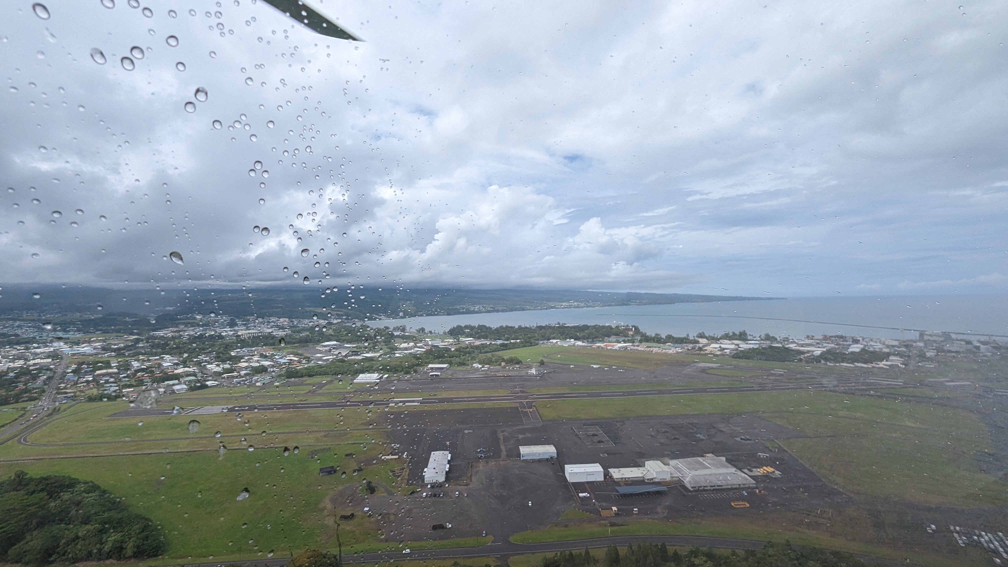
I mentioned in the last post in this series that I had a few photos from something I hadn't done before, and that turns out to have been “riding in a helicopter.” The final day my family was here visiting last year, we tried to take a helicopter tour of Kīlauea. Unfortunately, the weather did not comply; it was raining lightly when we took off, but the tour company thought we'd have a chance of making it out ahead of the clouds before we got to the volcano. However, a denser bit of weather rolled in faster than anticipated, and before we'd flown more than five minutes we were informed that it just wasn't meant to be that day and we had to turn back.

An upside is that they didn't charge us for the ten-minute helicopter flight we took, which was still a pretty neat experience. Riding in it felt exactly like how I'd imagined my drone must feel while flying, and while none of the photos I got during the trip were particularly great (due to the rain), I did snap a few of the area around the Hilo airport that I thought were interesting enough to share.

A shot looking over towards the UH Hilo campus (and Gemini facility), over the mall on the left.

View of the second runway at Hilo airport looking out over the bay.

Like I said, they're not the best shots, but it was really cool getting to see the ground from a height above where I can fly a drone and I always enjoy such opportunities. And with that failed outing, perhaps we'll have to try again in the future sometime. While I hate flying for long durations (on crowded airplanes, with no leg room…), I actually quite enjoy flying in short bursts.

Anyway, with this post series winding down, I've got some more post topics coming up due to the fact (which I can finally announce) that I spent two weeks over the end of January and beginning of February in Jordan, digging at an archaeological excavation and going on a few tours as well. Preparing for that trip was eating up a lot of my focus and energy in January, so now that it's over and I'm recovering from jetlag I can hopefully get some more posts out before too long. So keep an eye out! A hui hou!

Sunday, January 29, 2023

Miscellaneous family visit photos (part 2)

Part 2 of the miscellaneous photos series, these will cover more of the geological things we saw and places we visited.

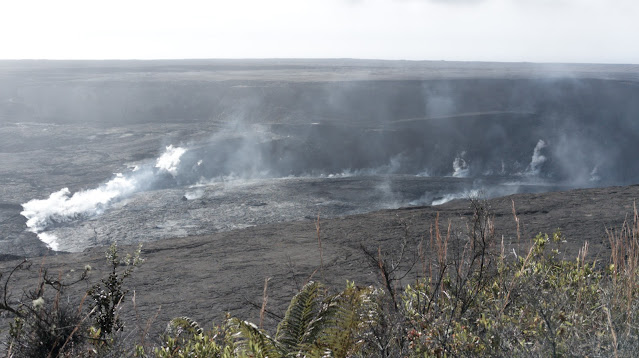
Two days before Mauna Loa awoke from its 38-year slumber, we visited Kīlauea in Volcanoes National Park. While I was there earlier last year, I hadn't actually gone to see the overlook of the (post-2018-eruption) caldera.  It was a pretty spectacular sight, as you could see giant cracks in the ground (visible near center-image below) where huge blocks of material had faulted and collapsed.

Kīlauea caldera. Sorry for the lens flare, the Pixel 7 Pro camera seems a bit prone to it.
The outgassing from around the crater floor that day was also pretty impressive:

Outgassing in Kīlauea caldera.

We also hiked the Kīlauea Iki trail, and I was able to get a nice photo back across the crater floor with hardly any people in it:

Kīlauea Iki crater floor.

I don't have too much to say about these photos since they're generally places I've seen and posted about before. We also visited Akaka Falls (for the first time since I got back), which was as impressive as always:

Akaka Falls.
It's still amazing to think about those fish (the ʻoʻopu) that are born above the falls, plunge down on their way to the ocean, then return and climb up the waterfall (along the rocks with suction cups) to breed. ʻOʻopu are hardcore. (For reference, Akaka Falls is 135 m high, and there are ʻoʻopu found at the top of 300 m high waterfalls elsewhere on the Hāmākua coast.)

Finally, stretching the definition of the post title slightly, here's a drone photo from November 29th, the day my family flew out and I went up to try to see Mauna Loa's eruption. This was taken when I flew out towards the lava, as in my video from last month. I couldn't see the lava very well on my controller screen so I didn't bother taking many photos, but in hindsight this is still a fairly cool photo and I should probably learn it's better to take a bunch of low-quality photos than to miss out on a potentially amazing one.

Lava rivers running down Mauna Loa's flank, November 29, 2022.

There may be one more post in this series with a few more photos, which will at least involve something new that I'd never done before. A hui hou!