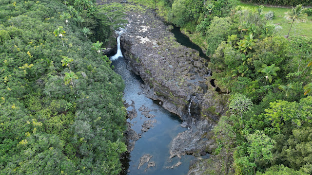
One unexpected benefit of flying drones around Hilo and up the Hāmākua coast is discovering waterfalls. The Hāmākua coast, lying on the windward side of Maunakea in the path of the prevailing trade winds, has some of the highest average annual rainfall values of anywhere in the world. Lava from Maunakea is also not very porous (which isn't true of Mauna Loa, which has almost no rivers on it), leading to a multitude of streams and rivers (many of them year-round) making their way down its slopes to reach the sea. The nature of that lava and its stratified layers also tends to result in lots of waterfalls along the way.
Some of these waterfalls are pretty famous (and rightfully so), or known tourist attractions, such as Rainbow Falls on the Wailuku river which marks the line between Maunakea and Mauna Loa lavas, or Akaka Falls a bit up the coast from Hilo on the Kolekole Stream. But something I've learned from flying around is that there are a lot more waterfalls along the various waterways of the Hāmākua coast, and I've been delightfully surprised at some of the examples I've randomly stumbled across.
For instance, here's a rather striking rock formation I discovered while flying up the Wailuku river in a portion that isn't easily accessible. This is actually only about 200–300 feet downstream from Rainbow Falls, but it's just around a bend from the official lookout platform such that I'd never seen it before. In fact, I have no idea just how many people have ever seen this particular part of the river – for being so close to a tourist landmark it really is quite isolated and wouldn't be easy to access on foot. Maybe from the right bank, where as you can see there's a private farm, but I don't know if there's any specific viewing area. (I've yet to see what it looks like when the river is in full flood, but I'm eagerly awaiting a large rainstorm to find out!)
But while the waterfall on the Wailuku river is probably not familiar to many people, it's at least on the edge of Hilo with a possible way to reach it from one side, and (crazy) people do occasionally kayak on the river. The waterfall above is on an unnamed tributary of Kawainui Stream, which sits between it and Waiʻaʻama Stream in a wild and untouched part of the Hāmākua coast, just a little ways south of Akaka falls. I found it entirely by accident while I was filming a timelapse video flying down the flank of Maunaka towards Hilo; at the end of it I looked down, and found this gorgeous little double waterfall. I was able to find it on Google Maps, and given its location in a thickly-forested area between two streams to the north and south, there really can't be many people other than pilots who've ever laid eyes on it.
I hadn't expected to find these picturesque waterfalls when I started drone, but it's really cool to be able to find ones that likely haven't been seen by many people before me, and then share them with the world. There are lots of places on this island I'm still looking forward to taking my drone, but it's also fun to discover these unexpected surprises. I'm sure I'll have more to share in the future, too! A hui hou!


No comments:
Post a Comment
Think I said something interesting or insightful? Let me know what you thought! Or even just drop in and say "hi" once in a while - I always enjoy reading comments.